- Total Miles: 3.13
- Time: 60 min
- Difficulty: Easy
- Best Season: All Year
- Elevation Gain: 551 ft
- Max Elevation: 1323 ft
- Type of Trail: Out & Back
- Parking Lot: Fits 30+ Cars
- Dogs: Allowed On A Leash
- Restrooms: Available At The Parking Lot
- Trail Popularity: Very High
- Pics Taken On: Nov 9, 2021
Mt Rubidoux is the most popular hike in Riverside County, and I can totally see why. The views from the top are amazing. To the north you can clearly see the Angeles and San Bernardino mountain ranges, and to the south, the Santa Ana mountains.
Mount Rubidoux Trail is a 2.7-mile hike in the city of Riverside, California. It’s an easy hike with only 393 feet of elevation gain. The Peace Bridge and cross at the summit are park relics.
Mt Rubidoux is one of many amazing hikes in SoCal. To explore 500 ft waterfalls, an abandoned zoo, nazi ruins, and more, check out the post below:
Best Hikes In Southern California
Mt Rubidoux Trail Map

Mt Rubidoux Trail Directions
Click the following link to be redirected to Ryan Bonaminio Park via Google Maps.
You’ll have to walk down San Andreas Ave to get to the trailhead.
Helpful Links
Open From Dawn To Dusk
Mt Rubidoux Trail
Arriving at the trailhead, you’ll notice the large sign (shown below) and a water station, which is nice considering you might get hot and thirsty on this hike.
This hike is definitely a sunny one! I recommend bringing a hat, water, and sunglasses to keep cool.
At the very beginning of the hike, you’ll notice the road splits left and right. Be sure to take the left road.

Most of the trail will be out in the open with little to no shade.
You’ll definitely get some awesome views of the surrounding city, though!

We eventually reached another split. You can choose to take the left and walk over the bridge if you’d like, but we chose to take the path on the right.
The road on the right curves and leads to to the tower first.

Here’s an awesome view of the Santa Ana River and the surrounding area. This is also a boundary between Riverside and Jurupa Valley.
The Santa Ana River is usually dry. The nice thing is you can see all the lush green trees from the water that occasionally flows through.

World Peace Bridge and Tower
This is one of my favorite parts of the hike.

This monument was built back in 1925, making it almost a century old!
It was actually inspired by a famous Roman bridge in Spain known as the Alcantara Bridge.
Here’s another angle with city views.
 The tower reminds me of princess Rapunzel.

Our next stop before the cross was the flag.
It’s positioned next to the Peace Tower and Bridge and located straight across from the Summit.

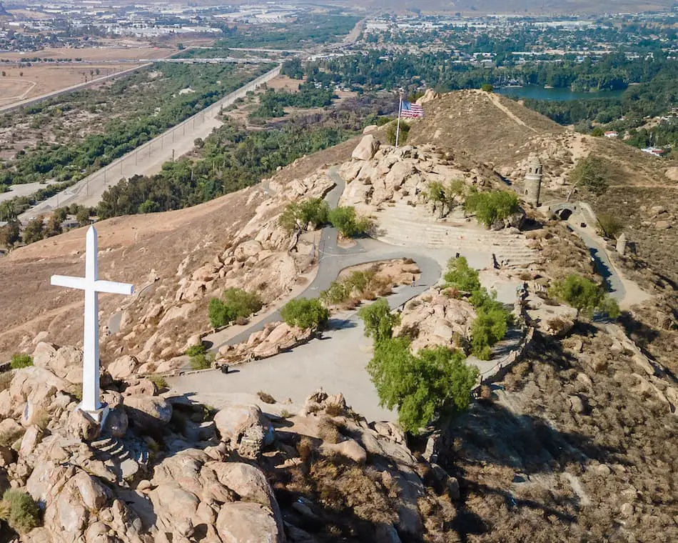
Last stop was the summit and cross!
The cross is HUGE. So big in fact, that we were able to spot it from the freeway.

Can you spot the flag and tower in the back?
Want to see more cool structures in Riverside County? Check out this giant Halloween pumpkin boulder!

We’re those tiny little ant-sized humans sitting on the bottom left side of the stairs.

The aerial views give you such a different perspective. It’s a truly amazing sight.

I hope we made you want to visit this place! It’s highly recommended and worth the drive.
Brief History of Mt Rubidoux

The famous cross that sits atop the Mt Rubidoux summit is far from new. It actually dates back to 1907, which was built to commemorate Father Junipero Serra.
They then developed the Peace Tower and bridge in the year 1934.

In 1946, the Mt Rubidoux property (formerly known as Puchappa Hill) was purchased by Henry E. Huntington, Frank Miller, and Charles M. Loring.
They had named it Huntington Park but later changed it to Frank A. Miller Mount Rubidoux Park after the park was donated to the city of Riverside in 1955.
Fast-forward to 2012, there was a legal battle and controversy over the cross being on city-owned property. This caused the top part of the property (including the cross) to be sold.
With the help of Riverside’s lovely community, they banned together in an organization known as Totally Mt. Rubidoux. It was a success and the cross is now a preserved historical monument that can be enjoyed by all!
Don’t you just love a happy ending?!
How Old is Mount Rubidoux?
The Mt Rubidoux land, formerly known as Huntington Park, was first purchased in 1906, making it over 100 years old. The property was donated to the city of Riverside in 1955.
Who Owns It?
A majority of the Mount Rubidoux Park property is owned by the city of Riverside. About 0.43 acres, including the cross, is owned by Rivers and Lands Conservancy.


