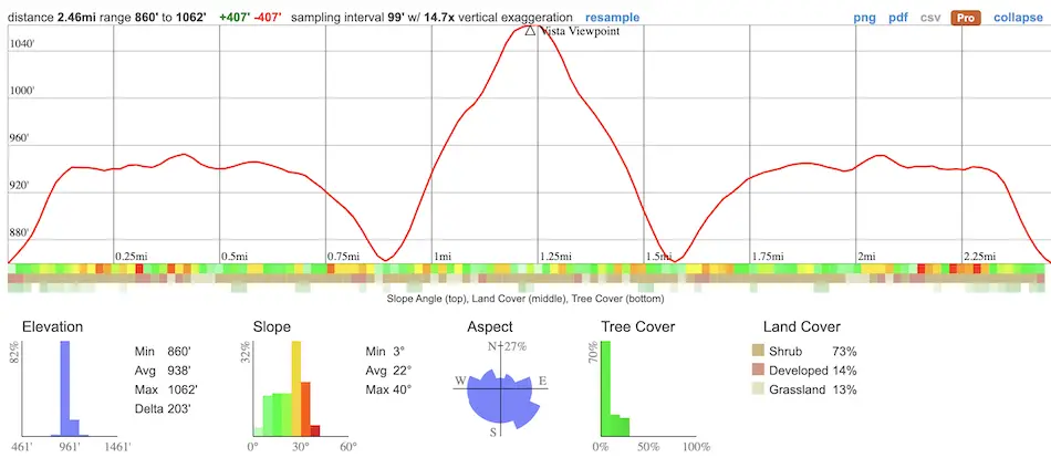
- Total Miles: 2.46
- Time: 1 Hrs
- Difficulty: Easy – Moderate
- Best Season: All Year
- Elevation Gain: 407 ft
- Max Elevation: 1062 ft
- Type of Trail: Out & Back
- Parking Lot: Fits ≈ 50 Cars
- Dogs: Allowed On A Leash
- Restrooms: Available At The Parking Lot
- Trail Popularity: Moderate
- Pics Taken On: Jan 16, 2024
Riverside Trail is a sunny dirt road nestled in the chaparral-filled hills of Griffith Park. The trail’s difficulty level has been rated as moderate to hard on All Trails, but I think it deserves more of an easy to moderate difficulty, as only the beginning and end are somewhat steep. Fortunately for beginners, the steep sections don’t last very long, as the majority of the trail boasts a mild ascent.
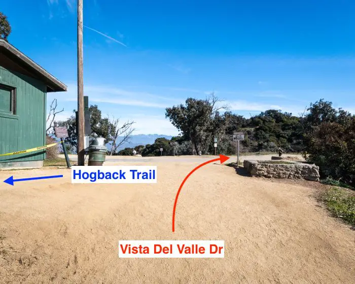
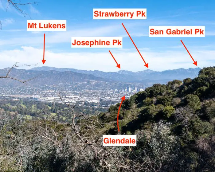
The trail ends at a turnout off of the paved road known as Vista Del Valle Dr, which translates as View Of The Valley in Spanish. From this viewpoint, one can easily see Downtown Los Angeles, Korea Town, and the Pacific Ocean if it’s a clear day. In my opinion, however, the view of the San Gabriels looming over Glendale, which can be seen from the place where Riverside, Hogback, and Vista Del Valle Dr. intersect, was more appealing and scenic. Maybe I’m just biased because I don’t like the city.
Want to explore abandoned gold mines, enormous waterfalls, and forgotten ruins in LA County? Click the link below. You won’t regret it!
Riverside Trail To Vista Viewpoint Map
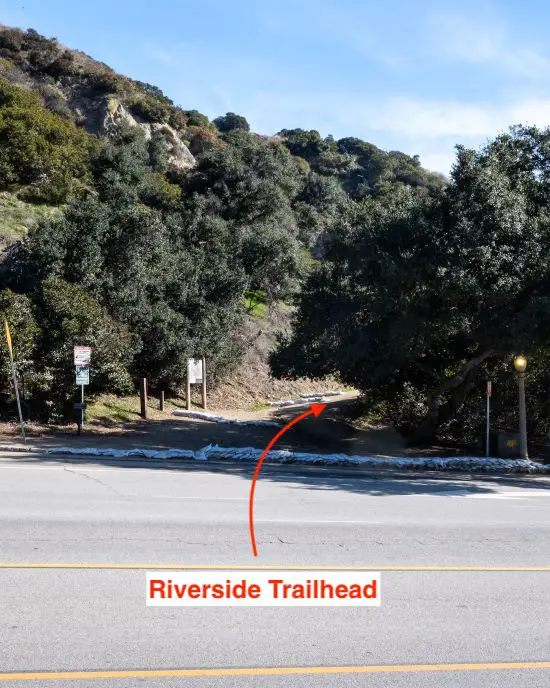
Parking & Directions
To be redirected to parking lot G, a lot belonging to the Greek Theater located directly across the street from the Riverside Trailhead, click the link here.
Note: Multiple people, myself included, have been able to park in lot G without paying a fee or getting a citation. However, I cannot guarantee this to be the case every time. If the Greek Theater is hosting an event, be especially careful, as they’re known to patrol and give out citations.
Helpful Links
Riverside Trail Weather Forecast
Griffith Park Additional Info & Maps
Hiking To Vista Viewpoint Via Riverside Trail
After parking in lot G, I walked across the street to begin ascending the dirt road known as Riverside Trail. Why the name Riverside? I couldn’t tell you. The canyon and surrounding hills are drier than a bag of Rapunzel fruit.
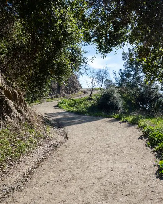
The trees at the trailhead are one of only two or three spots that provide shade on the hike. Hence, plan accordingly. The initial ascend is the steepest part of the hike, and only the very end gets close to rivaling the elevation gain.
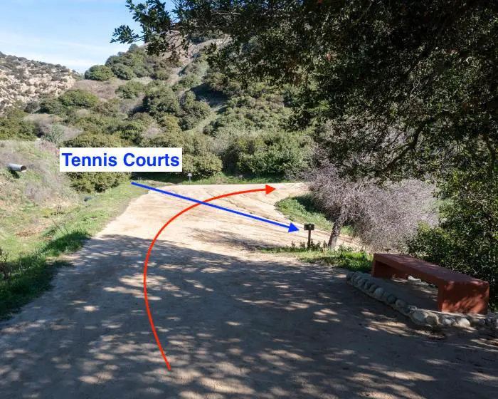
Since the tennis courts have their own designated parking lot, hiking to the courts from Riverside Trail is optional.
About halfway through the bend shown below, I noticed a dirt trail leading away from the road, but I ignored it as it ends after 650 feet.
I had no plans of playing tennis, so I continued up the same dirt road on which I started.
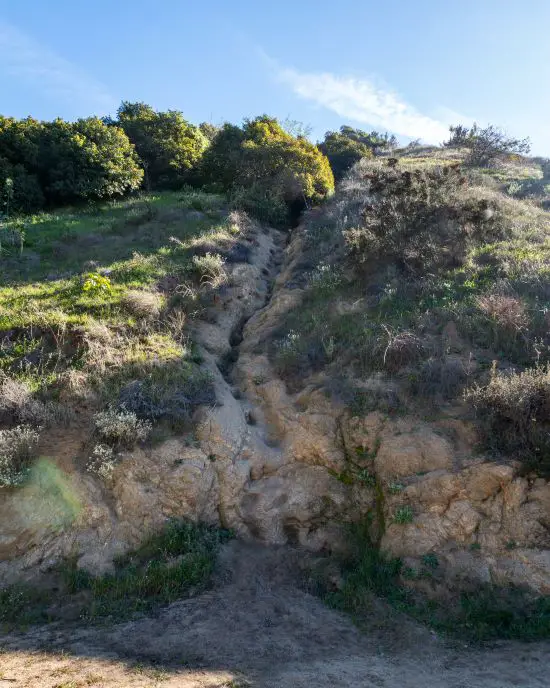
Little shortcuts and detours leading up the canyon wall are prevalent throughout the hike. The one shown below has been used so much that it morphed into a natural staircase.
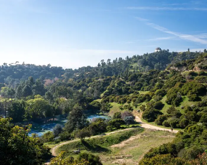
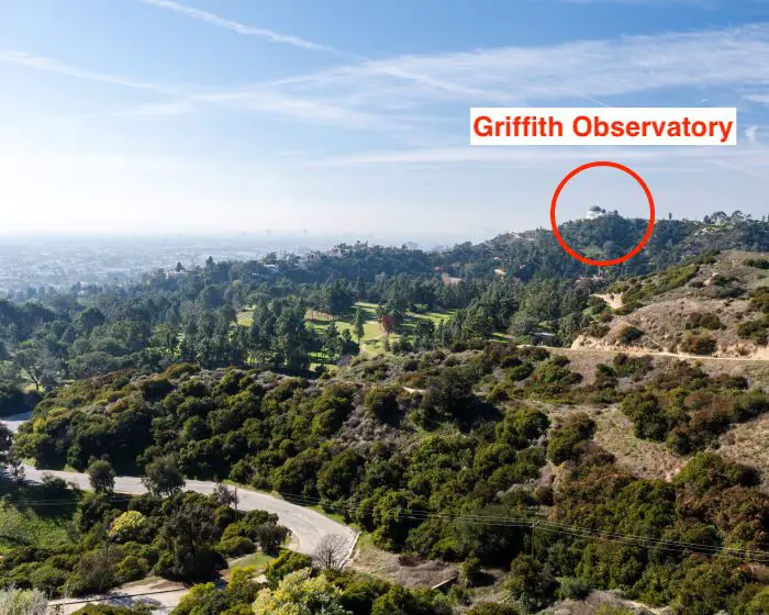
After a few minutes of hiking, I turned back out of sheer curiosity and was pleasantly surprised with the view. Griffith Observatory can be seen perched at the top of the hill, surrounded by vibrant green vegetation, and contrasted against a deep blue sky.
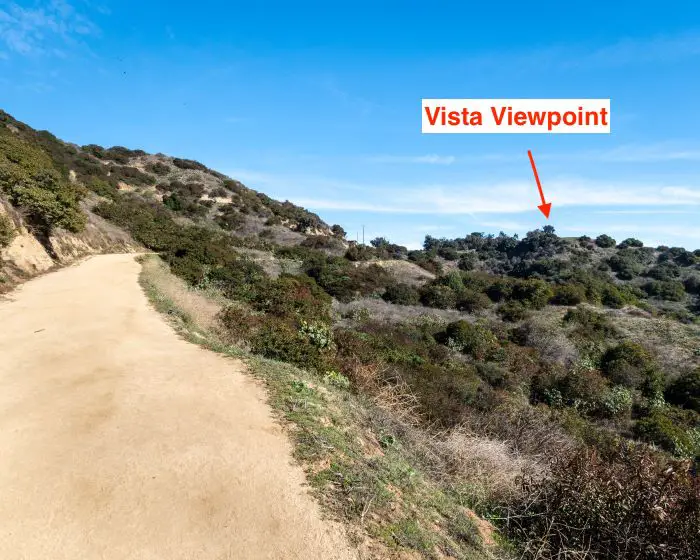
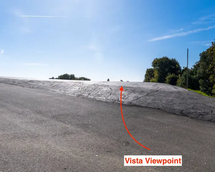
The last section of the trail increased its steepness once more, almost as if to say it’s not going down without a fight. Fortunately, the presence of Vista Viewpoint provided some moral support.
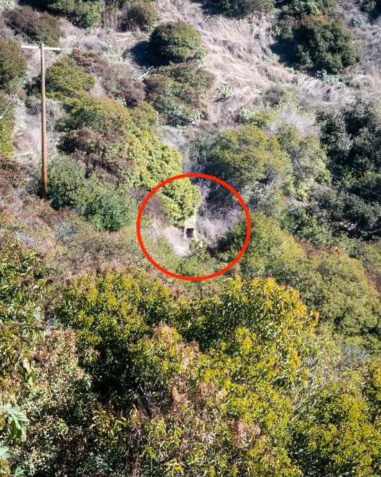
Shortly before arriving at the intersection of the three trails, I spotted stone ruins on the hillside underneath the viewpoint which resembled a chimney. Sadly, I’ve yet to find additional info.
I made a right onto the paved Vistas Del Valley Dr to get to the viewpoint. However, I crossed the paved road to admire the view of the San Gabriels and Glendale before doing so.
The Hogback Trail begins at this intersection, takes hikers underneath Glendale Peak, and ends shortly after passing Dante’s View. The Riverside and Hogback Trails can be combined with other trails to form an enormous loop.
The San Gabriel Mts can be seen below. I identified some of the more popular peaks.
After admiring the San Gabriels, I continued eastward on Vista Del Valley Dr. You can’t miss the viewpoint. It’s only like 30 steps eastward via the paved road.
Even with the horrible smog that day, the view did not disappoint.
From west to east, the first notable structure was the Griffith Observatory towering above the trees and golf course.
Moving eastward, Korea Town can be seen struggling to pierce above the horizon.
To the left of Korea Town, the unmistakable Downtown LA, and its lofty skyscrapers gaze down on the rest of the valley.
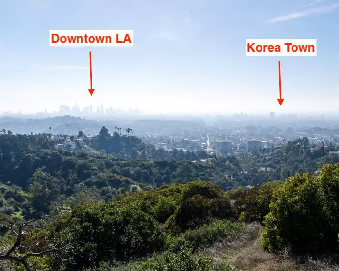
Last but not least, the view to the east includes the valley as far as the eye can see, which, on a clear day, would probably include Mt Gorgonio and the San Jacintos.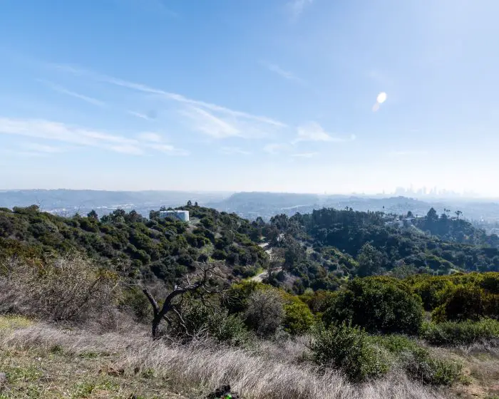
Hold on! Don’t leave just yet. Since this hike is super short, I combined it with another short hike which is only 5 minutes away from the Riverside Trail, ends at the Griffith Observatory, and offers better views! The first part of the hike will make you feel like you’re walking through a jungle!
Click the following link to see more: Ferndell Nature Trail To Griffith Observatory Loop