One of the most crucial aspects of hiking is the planning. Hiking apps can help you check the weather, distance, elevation, parking information and so much more.
However, as technology has progressed, hiking apps have become increasingly sophisticated to the point where they can identify peaks and constellations.
As a weekly hiker, I use various apps to ensure my hiking trips run smoothly, and also to provide the best possible content for my readers.
Here are few amazing features you can expect from the following 10 best hiking apps for Android and iPhone:
- record your route using GPS
- hike details (distance, elevation gain, etc)
- direction of sunlight & moonlight at any given time
- identify peaks, planets, stars, and constellations
- share real time location offline
- send emergency notifications to family and friends
Best Trail Apps For Hiking:
- All Trails
- Gaia
Best Free Hiking Apps
- All Trails
- National Park Trail Guide
Checkout the links below for more posts on hiking guides and gear!
- 15 Best Hiking Songs to Get You Pumped on The Trail
- 11 Tips For Planning an Amazing Hiking Trip
- What to do If You Get Bit by a Snake While Hiking
- Can Hiking Boots Be Used in the Snow?
- 10 Tips For Hiking Alone
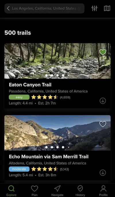
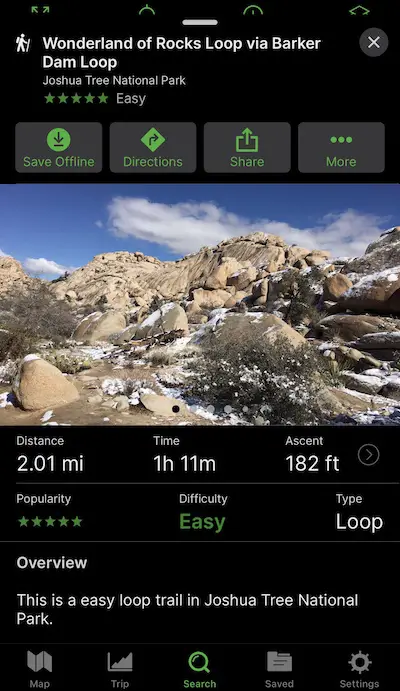
1) All Trails
Price: Free Version or $29.99/year
If you only download one hiking app, make sure it’s AllTrails. The free app offers specific info for each hike including elevation gain, distance, type of hike, accurate weather forecast and more.
The information for its 100,000 trails is provided by 10 million users from over 100 countries. Once you make an account, you too will be able to record and share new and existing hikes with others on the platform if you choose to make your information public.
All members can upload images for others to see.
Once you’ve completed the hike, you can leave a review with your thougths and rate it 1 to 5 stars. The reviews are shared at the bottom of the page and the average is shown on the featured image for everyone to see.
By clicking on the directions button at top lefthand side, All trails provides directions to the trailhead via your choice of Apple Maps or Google Maps.
Once you’re at the trailhead, you can begin to record your journey on the GPS map.
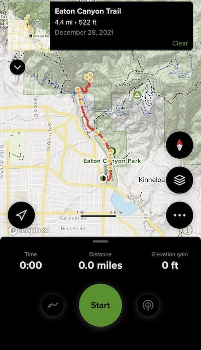
AllTrails also helps you track your activities and organizes the performance data for each month.
The Pro version, which costs $29.99 per year, allows you to download offline maps and sends you notifications if you go off the trail.
- Play Store
- App Store
Pros of AllTrails:
- Free
- Design, save, and create custom maps
- User-friendly interface.
- Preloaded trails are available.
- Record and save hikes
- Off-roading trails available
- Information for planning
- Reviews
Cons of AllTrails:
- Must annually subscribe to access the offline maps
2) Cairn
Price: 30 days free, then $4.99 for 1 month or $2.25 for 12 months
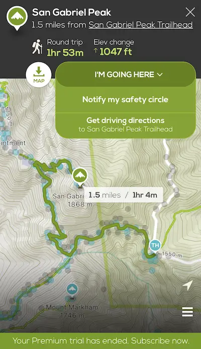
Cairn is considered one of the best hiking safety application, which is why it always stays on my phone.
Cairn allows you to share your plans with family and friends via a feature called your “safety circle.” Your safety circle is a list of contacts that the app will notify if you fail to report by a certain time.
The app also allows you to find spots with cell coverage, download offline maps, and track your location and share it with contacts. The location is NOT shared when you’re offline. Instead, it’s updated every time your phone gets signal.
The free version allows full access to all features for 30 days.
- Play Store
- App Store
Pros of Cairn:
- Live tracking
- Safety contacts are notified when you’re past due
- Rescue advice
- Download maps
- Find cell coverage on maps
- Hike details (distance, elevation gain, etc)
- Record and save your trail
- Send status updates
Cons of Cairn:
- Monthly subscription required after 1 month
3) Adobe Lightroom
Price: Free Version & $9.99/month
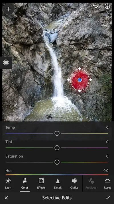
You’re probably wondering why I named Lightroom as the third app, but trust me, this app is a must.
Lightroom allows you to enhance your photos to a much higher degree than the editing tools in your phone or social media. The free version allows you to use the majority of the key functions, with the exception of masking.
The paid version cost $9.99 per month and also includes Photoshop.
When you look at really nice shots on Instagram, I’m willing to bet there’s at 99% chance they were edited with Lightroom.
Don’t believe me? Check out this before and after shot I took of a secret mine in Pasadena, California.


The app is fairly simple to use and understand. It’s knowing how to combine certain edits that requires practice.
However, if you’re not in the mood for manual editing, Lightroom offers an auto feature that does a phenomenal job at editing the images for you.
Pros of Lightroom:
- Professional editing
- Offers presets
- Cloud storage
- Auto editing feature
- Free version offers most features
Cons of Lightroom:
- Requires a bit of practice
4) Peak Visor

Price: Free Version & $29.99/year or one $74.99 lifetime payment
PeakVisor is a really neat application that can identify peaks, and help you plan your hiking routes.
It uses a combination of location tracking, a phone camera, and an accurate 3D mountain panorama to recognize the mountains. The app also offers a compass.
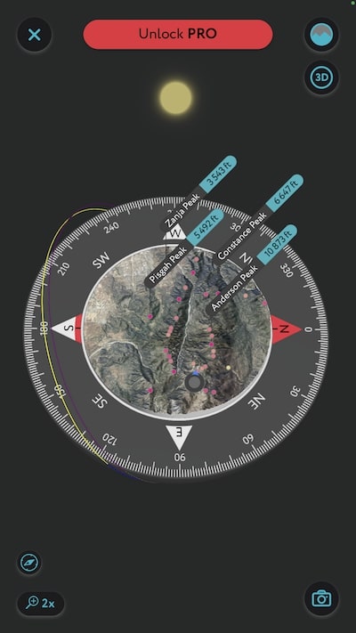
You don’t have to physically be in an area to explore it on Peak Visor. The app allows you to search mountain ranges worldwide from a 3 dimensional point of view.
You can also see the peak’s detailed information, such as the topographic prominence, altitude, national parks, reserves, and mountain range.

Unfortunately, the free version is limited to 1 location a day. For unlimited daily searches, PeakVisor offers a $29.99/year package or a lifetime deal with one payment of $74.99.
- Play Store
- App Store
Pros of PeakVisor:
- 3D map navigation
- Peak identification & details
- Compass
- Plan hiking routes
- GPS tracker
- Offline service
- 3D maps for winter resorts
Cons of PeakVisor:
- No live data tracking feature
- Free version offers only 1 free search per day
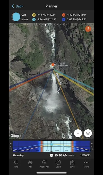
5) PhotoPills
Price: $9.99
Have you ever been super excited about hiking to a beautiful destination, only to get home and realize all your shots look terrible? That’s because photographers know it’s all about timing.
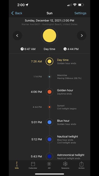
Light is a huge factor when it comes to taking amazing pictures, and PhotoPills allows you see see the exact location of the sun and the moon at any given time and place as well as the direction of the light they emit.
You don’t have to be a professional to use PhotoPills, but it’s nice to know for example, if you show up at a waterfall at 4 pm when the sun is lighting up the falls, that your pics are going to look significantly better. The same goes for peaks and ruins.
The app also shows you the location of the MilkyWay in 3D augmented reality, the exact time of sunrise, sunset, twilight hour, golden hour, moonrise/set, and so much more.
PhotoPills is without a doubt one my favorite and most useful tools for the outdoors.
- Play Store
- App Store
Pros of PhotoPills:
- Calculates long exposure, timelapse, spot stars, star trails
- 3D augmented reality of Sun, Moon, Milky Way, Celestial Equator, Polaris
- 2D map planner for the sun, moon, and Milky Way
- Location scouting tool
- Photo plans manager
- Key info: sunrise/set, moonrise/set, blue hour, golden hour, supermoon dates, moon calendar
Cons of PhotoPills:
- One time payment of $9.99
- A bit complex to use
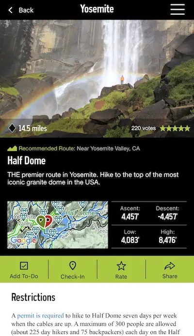
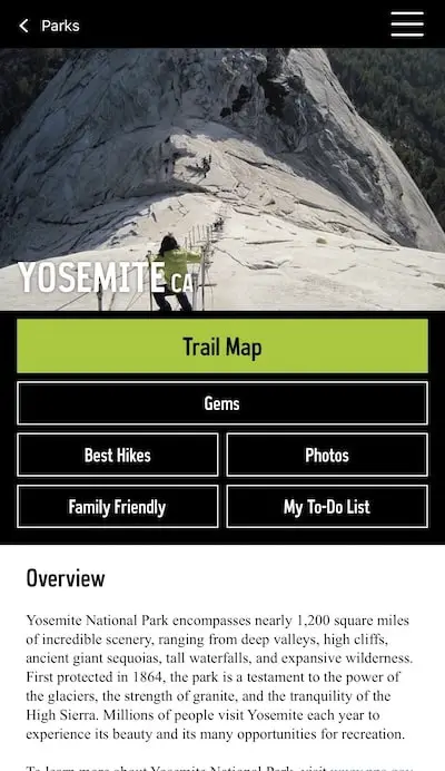
6) National Park Trail Guide
Price: Completely FREEEE
You’re going to love this app because of the comprehensive information it provides about your favorite national parks. It offers inside tips on campsites, permits, food, and so much more.
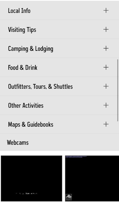
Unlike many other apps, NPTG lets you see all the data and GPS map offline…for FREE!
Many of the app’s features are similar to those of All Trails such as tracking your hikes and the hike details.
However, unique features include a list carefully selected family hikes, creating your personal to-do list, gems and sending your exact location in case of an emergency.
The app is super easy to navigate and extremely helpful.
Pros of National Park Trail Guides :
- Completely free
- Live position on satellite or terrain map
- Can be used offline
- List of family friendly hikes
- Create personal to-do list
- Share location incase of emergency
- Hike details and ratings
- Track hikes
- Visiting tips
- Camping and lodging info
- Easy to use
Cons of National Park Trail Guides:
- None
7) PictureThis

Price: Free Version & $29.99/year
Have you ever wished you could easily identify various plants during your hikes? Well now you can.
PictureThis is an educational app that help 70 million users identify over 1 million plants, flowers, and tree species with a 98% accuracy. It’s super useful, especially for differentiating between safe and poisonous plants.
All you have to do is snap a picture of any plant with their easy-to-use built-in camera. After taking the shot, you’re provided with the plant’s info and the option of saving your photo on your phone.
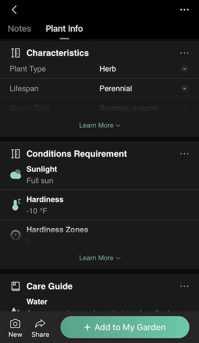
The premium version offers unlimited ID’s, plant care guides, and access to expert botanists.
Pros of PictureThis:
- Easy to use
- Identify 1,000,000+ plants
- Save photos with plant info on phone
- Diagnose plants
- One on one conversations with botanists
- Keep notes and records
- Bird and insect identification
Cons of PictureThis:
- Identification is not always accurate
- Must pay to get full access to get all of the features
8) Google Earth

Price: Free
I was planning on keeping this a secret, but I’m completely committed to providing you with the best hiking apps. So, here it is.
Google Earth is the app I use to find hidden gems. The app allows you to see the entire world from a 3D point of view similar to PeakVisor.
However, Google Earth allows you to see more detail in the terrain. You can also tilt the map so that you’re looking at a mountain range from a more face-to-face point view.
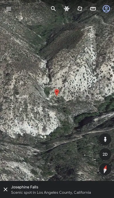
These advantages can help you spot waterfalls and long forgotten ruins that are sometimes located near your favorite trails.
- Play Store
- App Store
Pros of Google Earth:
- Completely free
- 3D map of the world
- Detailed terrain
- Great for finding hidden gems
Cons of Google Earth:
- None
9) Gaia
Price: Free Version & $39.99/year
Gaia GPS is another app similar to All Trails. The two provide very similar features.
Gaia allows you to track your speed, provides the highest points, elevation graphs, and supports road maps, satellite maps, and topographic maps. A premium membership is required to download maps for offline use.
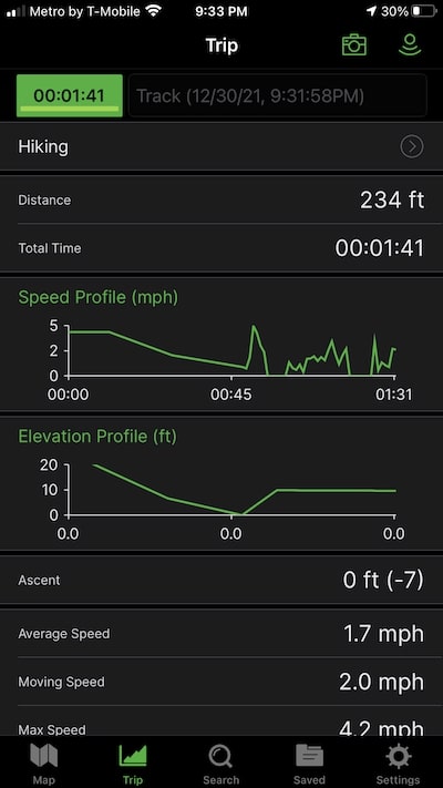
The GPS tracking feature can be used offline. Most people use All Trails, but they both have their pros and cons.
For example, I find the All Trails interface easier to use, but Gaia’s trail information is more accurate because it doesn’t crowdsource its information. All Trails offers more hikes because it has more users.
- Play Store
- App Store
Pros of Gaia GPS:
- Hike details (distance, weather, etc)
- Maps online & offline
- Info for hunting, camping, mountain biking, & more
- Accurate information
- GPS tracking
- User reviews
Cons of Gaia GPS:
- Subscription required to download maps
- Less trails than All Trails App
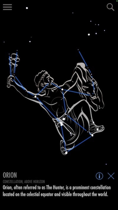
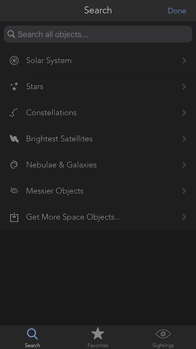
10) Skyview Lite
Price: Free Version & $2.99
Skyview Lite is a free application that identifies planets, constellations, and galaxies in the night sky.
With 27 million downloads, Skyview is undoubtedly popular among the outdoor communities. Its easy-to-use interface allows you to stargaze via augmented reality by simply holding your phone up to the sky.
Other features include reminders for celestial events and daily sky tracks for the sun or the moon. You can do all this without Wifi.
The paid version cost $2.99 and includes more stars, constellations, planets, and satellites.
- Play Store
- App Store
Pros of SkyView Lite
- Identify stars, satellites, constellations, planets, galaxies
- Get notified about stargazing events
- Easy to use
- See the sky as it was in the past or future
- Infrared display allows you to conserve your natural night vision
- Track trajectory of any celestial object
Cons of SkyView Lite:
- Free version is limited in the # of identifiable objects
Why You Should Use Hiking Apps
You can technically hike without using apps, but believe me, they’ll enhance your outdoor experiences.
Here are just a few reasons why I think you should become accustomed to using hiking apps:
Navigation
When you’re in the outdoors, there’s always the possibility of losing the trail or worse, getting lost. Wether you’re online or offline, hiking apps’ advanced GPS can easily help you stay on-course, and potentially avoid a life threatening situation.
I still suggest carrying a physical map incase your phone battery dies, but it’ll only be for backup.
Information
Nowadays, a smartphone isn’t just a phone, it’s a mobile encyclopedia. Make the most of your hikes by identifying plants, animals, constellations, and nearby peaks.
We have the potential to become outdoor experts with the help from a device that fits in our pockets.
Save Metrics
Some of the hiking apps that I discussed feature tracking options that record your performance metrics and allow you to share this data with other outdoorsmen and outdoors women. It’s a fun way to encourage friendly competition, and self improvement.
Convenience
Apps are great for planning. Instead of Googling and memorizing nearby hikes, you can conveniently create lists on All Trails or Gaia consisting of your favorite trails.
Not to mention the various books you’d have to carry to identify plants, wildlife, and constellations. You simply can’t beat the conveniency.
Emergencies
If you happen to get lost or injured, certain hiking apps will notify your specified contact list. The apps also provide detailed instructions regarding what to do in various emergency situations.
All Trail’s Pro feature, Lifeline, allows you to share your real time location with loved ones wether you’re online or offline. Yep, they’re that amazing.
FAQ’s
Is There a Difference When Using The Same App on iPhone or Android?
The difference between apps on these phones is actually a highly debated topic. Most would agree that iPhone apps are better and tend to have better or more features than Android apps.
That’s not to say that Android apps are not good, but it’s definitely something to keep in mind.
All Trails vs Gaia
I prefer All Trails for two reasons. First and foremost, I find the interface easier to use. Second, it contains more trails because it has more users.
Gaia’s information is more accurate because it doesn’t rely on crowdsourcing. However, I’ve rarely encountered incorrect information on All Trails (one time to be exact, the city was incorrect).
If those two reasons aren’t enough, All Trails now offers their amazing (and paid) Lifeline feature, which keeps you and your loved ones connected in REAL TIME, should an emergency occur.
Which Apps do You Recommend as Necessities?
If you wanted to download the least amount of apps, I recommend All Trails (preferably the paid Pro version). This app alone provides everything you need including:
- Online maps
- Offline maps (Pro)
- Lifeline (Pro)
- Hike details (distance, elevation gain, etc)
- Performance tracking
- Weather forecast
- Reviews & images
- GPS
This is definitely an essential app I use EVERY single time I plan a hike.
Which App Offers The Best GPS For Hiking?
Gaia has the best GPS features for hiking. Gaia’s trail information is more accurate because it doesn’t crowdsource its information and instead provides the user with more accurate and researched guides.
Can I Use Google Maps For Hiking?
You can use Google Maps to search for certain locations and to get a general idea of the area. However, I don’t recommend using Google Maps as a complete guide to a trail because it doesn’t give you a detailed outline of the hike like other apps offer.


