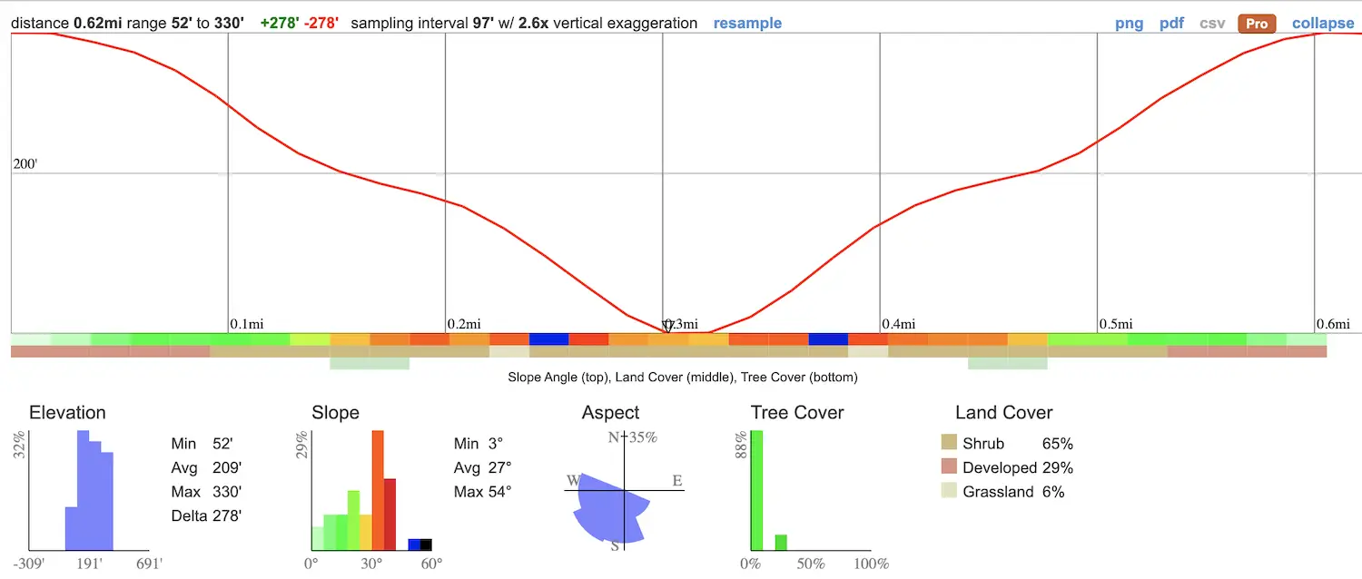
- Total Miles: 0.62
- Time: 20 min
- Difficulty: Hard
- Best Season: All Year
- Elevation Gain: 278 ft
- Max Elevation: 330 ft
- Type of Trail: Out & Back
- Parking Lot: Street Parking
- Dogs: Not Allowed
- Restrooms: Not Available
- Trail Popularity: High
- Pics Taken On: Sept 28, 2022
I hope you guys are ready for a one of a kind adventure because there are very few hikes like this one!
Named by local surfers in the 1960’s, the Ho Chi Minh Trail (AKA Saigon Trail) in La Jolla is a short and technical trail that leads hikers through a beautiful slot canyon, steep ruts, and loose sandy ledges. In order to complete the journey, a rope must be used to descend onto the (clothing optional) Black Beach where a little luscious waterfall flows over the side of the sandstone cliff.
Want to explore more slot canyons, the largest SoCal falls, nazi ruins, and more? Check out the post below:
Best Hikes In Southern California
Address & Directions
Click the link to be redirected to the trailhead on Google Maps.
9883 La Jolla Farms Rd, La Jolla, CA 92037
Helpful Links
Ho Chi Minh Trail
The trail begins in a quiet neighborhood via a small dirt alley between private properties.
It’s quite a popular route for surfers and those paying a visit to Black Beach.

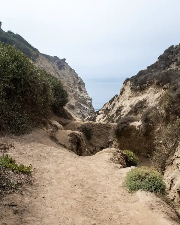
Almost instantly you’ll enjoy amazing views of the canyon and the ocean.
The trail ascending up the canyon wall is one of two detours leading up to a viewpoint with stunning views of the beautiful Pacific Ocean.

When you reach the canyon floor, you’ll come across the infamous plank.
Luckily, it’s only about 3-4 feet above the ground, so if you don’t want to risk an injury, you can make your way down to the bottom and climb back up the other side.


This is the spot where most people take the wrong path. The correct way is to stay left, above the first slot canyon.
However, some people, like yours truly, intentionally climbed down to explore a bit more.
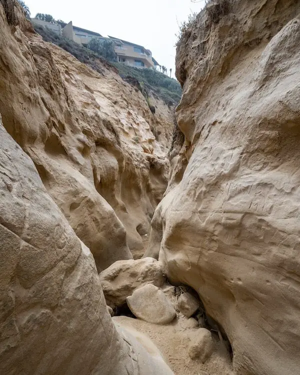
If you do decide to climb to the bottom of the first slot canyon (shown below), you’ll notice the walls closing in on you and a tall ledge marking the end of this detour.
You’ll have to turn back and climb back up the way you came to continue on the main trail.
Explore a hike with multiple swimming holes and a secret waterfall in SD County? Check out the post below.
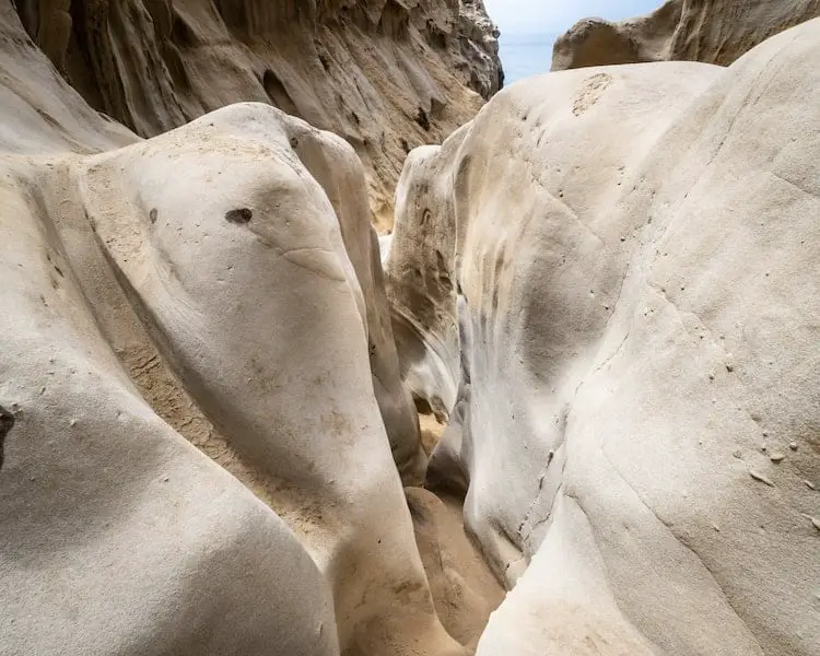
Now that you’re back on the main trail, you’ll quickly arrive at the famous slot canyon where most people take pics.
The formations are other worldly, with the top of the slot canyon looking like a human brain (or maybe it’s just me).

There it is, the main attraction.

The last section of the trail begins to show signs of life as it runs parallel to the creek which now boasts running water and mossy decorated banks.
The end is officially in sight.

Before climbing down the canyon mouth, you’ll notice water running down the cliff wall to your left and an abundance of vegetation surrounding the area.
Oh, it gets better.

However, to be rewarded with a tropical paradise and waterfall, you must prove you’re a worthy adventurer by climbing down to the beach using a rope left behind by the locals.

The 12ish foot waterfall may not look like much, but the treasure lies in its uniqueness.
Few waterfalls flow directly onto a beach, as this one does, and when coupled with another rare attraction, a slot canyon, this hike literally is one of a kind.
SoCal’s most beautiful waterfall is also located in San Diego County, and it has the largest swimming hole I’ve ever explored. Check it out, click the link below:
80ft Cedar Creek Falls & Huge Swimming Hole


