
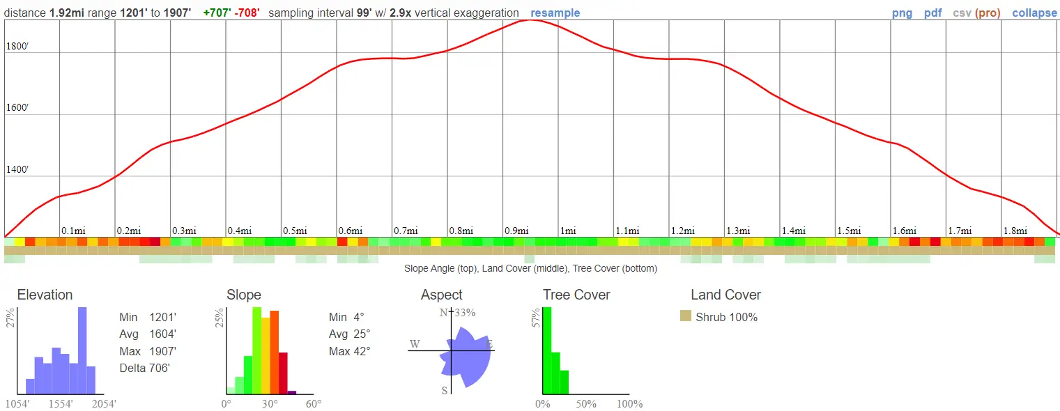
- Miles: 1.92
- Time: 45 min
- Difficulty: Moderate
- Best Season: All Year
- Elevation Gain: 707 ft
- Max Elevation: 1907 ft
- Type of Trail: Out & Back
- Parking Lot: Turnout, Fits ≈ 20 cars
- Dogs: Allowed on a leash
- Restrooms: Not Available
- Trail Popularity: Low – Moderate
- Pics Taken On: Feb 28, 2023
If you’re looking for a quick hike to sneak in right after or before work then look no further than Mystic Canyon Trail. I’ve hiked and biked (yeah that’s me in the featured image) this trail more times than I can count, and one of the things I love most about it is how accessible and thus, ideal, it is for a midweek.
The trail is a short, fun hike located in Glendora, CA that offers amazing views of the city below, and ends at a hoisted American Flag. Mountain ranges surround the viewpoint on three sides, and the ocean can be seen to the south on very clear days. There is very little shade on this trail. Hence, a hat and plenty of water is highly recommended.
Need more hiking ideas in Los Angeles county? Check out the complete list below!
Mystic Canyon Trail Map
Address & Directions
Click the link to be redirected to the Mystic Canyon Trailhead via Google Maps.
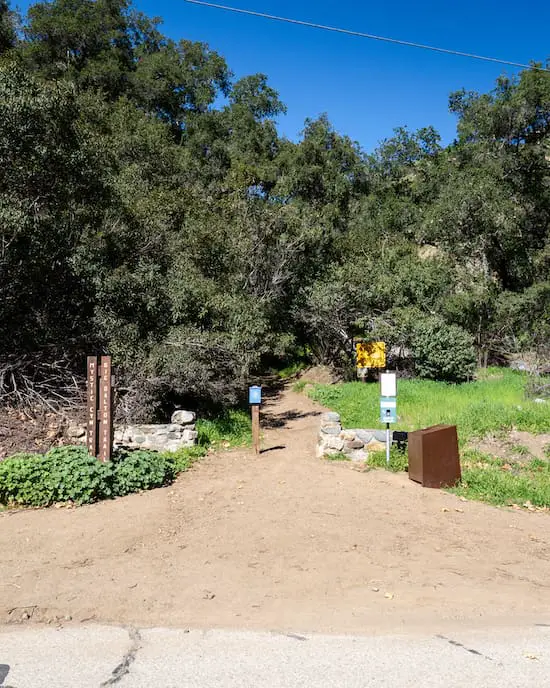
After clicking the link, you may notice I linked to the Big Dalton Canyon Trailhead, but that wasn’t a mistake, as both hikes share the same trailhead. I parked in the dirt lot off of Big Dalton Canyon Rd.
Helpful Links
SoCal Adventure Pass (required for parking in CA mountains)
Mystic Canyon Trail
Almost as soon as as I walked passed the trailhead, I came to a T intersection. I made a left, and the elevation immediately began increasing.
From this point forward there are only small pockets of shade so enjoy it. I found the beginning of the trail to be very rutted, steep, and the dirt loose. Also keep an eye out for cyclists as the trail is very popular with mountain bikers.
Trust me, I used to frequently bike this trail, especially during the fall and winter, when the Snow Summit Bike Park closes down for boarding season.

The views of Big Dalton Wilderness Park were exceptional as I made my way to the top.

Shortly thereafter, I got a glimpse of the Big Dalton Debris Basin, which, like its name suggests, is responsible for catching the gravel, boulders, and sediment from traveling downstream from the Big Dalton Reservoir.

As I made my way further up the trail the views kept getting better.

To the east, the king of the San Gabriels, Mt Baldy, peeked over the vibrant green mountain ranges.
Want to visit a much shorter, snowy peak instead of Mt Baldy? Check out Sunset Peak in the vicinity of Mt Baldy, a long and easy dirt road from beginning to end.

The flagpole loomed in the distance as I got closer, while Laurel sumac and California Sagebrush, two of some of the most popular plants, adorned the sides of the trail.

The last part got a little rutted, but nothing too bad. Regardless, I was careful to watch my step, as it doesn’t take a deep rut to strain your ankle.
If you’re not already using hiking boots with ankle support, do yourself a favor and invest in a pair.

Here is the view from the top. I could easily see the entire city of Glendora. I hiked back the exact same way I got to the top.

I’ve biked down the road heading south from the flag, and it’s very steep and loose. I don’t recommend it for most people. Additionally, it ends at the intersection of Big Dalton Canyon Rd and Glendora Mountain Rd (GMR), which means you’ll have to walk back Big Dalton Canyon Rd to get to the dirt lot.

Since we received major storms during the 2023 winter season, the mountains were greener than I’ve ever seen them. That’s snowcapped Mt Baldy in the back.

The road heading west is the Lower Monroe Truck Road. If you head down from this road, you’ll end up back on GMR.

However, if you head up from the Lower Monroe Truck Rd, you’ll end up on the Punk Out Trail, or as well call it in the biking community, “The Poop Chutes”.

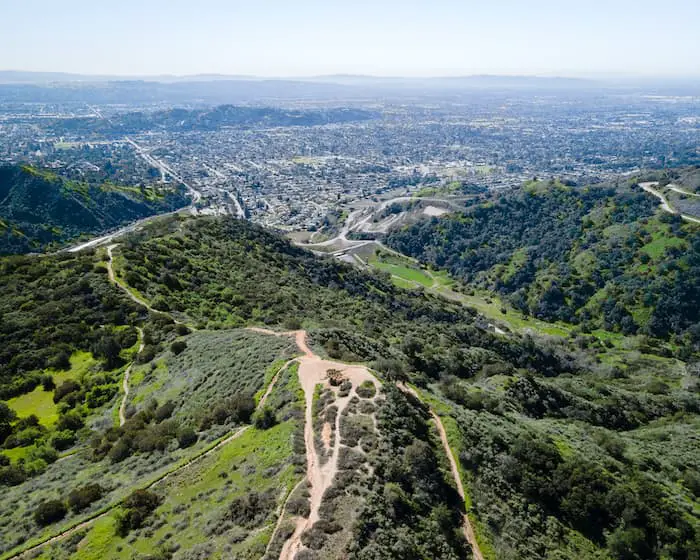
Here’s one more drone shot of Mystic Canyon with a view of the valley below.
Not sure if you want to hike Mystic Canyon, but still in the mood for nearby lookout? Check out Claremont Loop, an easy 5 mile trek in the foothills of the Angeles Forest.


