Los Angelinos have been in love with hiking since the late 1800s. With the never-ending list of trails growing each year since the hiking boom at the turn of the 20th century, finding the best hiking trails in Los Angeles can be daunting.
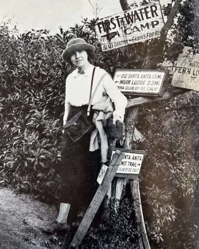
But not to worry, I’m here to help! I grew up in the foothills of the Angeles National Forest where I spent the majority of my weekends hiking, biking, and snowboarding. I’m here to share with you what I think are the five best hikes in LA.
Before we continue I’d like to ask one favor from you. Please keep these gems clean. Whatever you pack in, pack it out. If we don’t take care of our mountains, no one will. Thank you in advance!
Okay, get your boots ready because after reading about these hikes you won’t be able to resist checking them out!
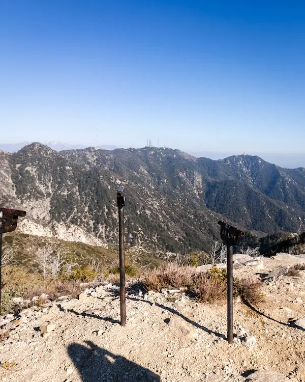
11) Mt Lowe Peak: Amazing Panoramic Views
- Total Miles: 3.2
- Elevation Gain: 295 feet
- Map, Directions, & Full Post: Mount Lowe Peak
Mount Lowe Peak, is (in my opinion), named after one of the greatest Californian innovators and entrepreneurs, Professor Thaddeus Lowe, and offers beautiful views ranging from the valley below to Catalina Island.
From the trailhead, I was rewarded with amazing views of the Eaton Wash and the valley below me, and once I got to Markham Saddle, Bear Canyon loomed in the late evening light.
From Mt Lowe Peak I could clearly see the famous Mount Wilson Peak, home of the famous 100-inch Hooker telescope to the west. To the north San Gabriel Peak towered above me. It’s an amazing place for a sunset.
Keep in mind Mount Lowe gets snow. If there has been recent snowfall, you may need to take microspikes or crampons.
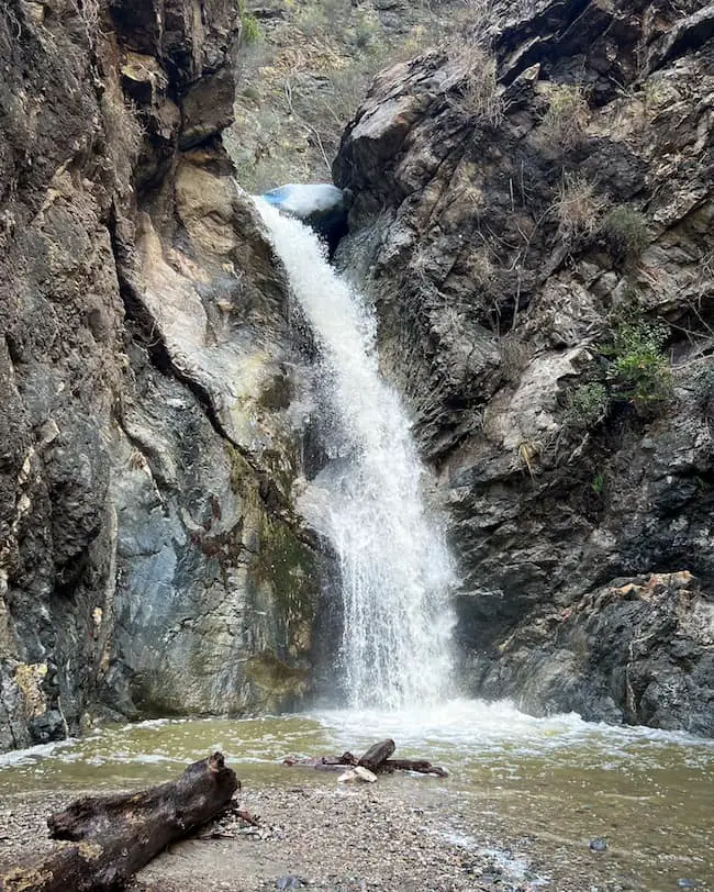
10) Eaton Canyon Falls: LA’s Most Popular Cascade
- Total Miles: 4.02
- Elevation Gain: 455 Ft
- Map, Directions, & Full Post: Eaton Canyon Falls
Eaton Canyon Falls has been a very well-known place for many years. The Spanish called it “Canon Precipicio,” which translates to The Precipice Canyon, and arguably the greatest conservationist of all time, John Muir, described it as the Yosemite of the San Gabriels.
Fun Fact: The waterfall has three trailheads, so be sure to check out the full post to learn which trail is best for you.
Some of the things I love most about Eaton Canyon are the very vertical canyon walls and scenic trail. White Alders adorn the banks of the creek in many locations.
Keep in mind there are multiple creek crossings on the trail, some of which are a bit long (like 10-20 feet depending on the time of year), but luckily they’re not very deep nor dangerous.
The fifty-foot waterfall can be heard roaring from the time I got around the last two bends and is an incredible sight to see. Remember, this is the most popular waterfall in all of LA County, so be sure to arrive early if you want to avoid enormous crowds. If you arrive at the trailhead at 8 a.m., expect tons of people.
I’d get there by 6 am at the latest, and for those who don’t like to wake up early, try visiting during the week instead of weekends.
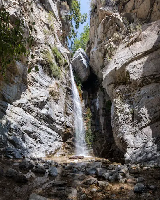
9) Trail Canyon Falls: Crown Of Big Tujunga
- Total Miles: 4.5
- Elevation Gain: 1067 Ft
- Map, Directions, & Full Post: Trail Canyon Falls
Located deep in Big Tujunga Canyon, the drier western part of the San Gabriel Mts is a gem that all hikers need to add to their list.
The trail began on a dirt road that led me through private properties (so please be respectful), and later converted onto a dirt trail that ascended up the side of the canyon before dropping back down onto the canyon floor at the end of the hike.
Fun Fact: There are multiple seasonal waterfalls on this trail which only flow after a good wet season. Check out the full post to see pics.
Towards the last part of the hike, I climbed down a loose and nearly vertical section of the trail, as it was the only way to get to the base of the falls. It’s about a 20 foot descent, but luckily people have left ropes for others to use.
The waterfall measures roughly 40 feet and is adorned with vibrant green plants.
It’s possible to explore the top of the falls by not climbing down to the canyon floor at the end of the hike and instead, continuing via the same trail.
8) Hollywood Sign: Amazing City Views
- Total Miles: 6
- Elevation Gain: 1174 Ft
The Hollywood Sign hike is a must-do for all locals and tourists alike. Although the trail may not be the most scenic or greenest trail in the county, the views of the city from the top are worth it.
Take plenty of water and a hat because it gets really hot during the summertime!
Fun Fact: Since the Hollywood Hike sign shares the same trailhead with the Bronson Caves (the caves have been used in a wide variety of movies including one of the Batman movies), I highly recommend doing both.
The trail ends behind the Hollywood sign as shown in the featured image above.
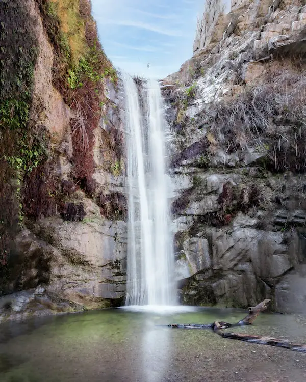
7) Millard Canyon Falls: Altadena’s Local Gem
- Total Miles: 1.3
- Elevation Gain: 308 Ft
- Map, Directions, & Full Post: Millard Canyon Falls
Millard Falls is a scenic tranquil escape in the foothills of the San Gabriel Mts. The shaded trail begins at the campground and follows the creek upstream to the falls.
I love this trail because of how green and vegetated it gets during the spring and summer. Western Sycamore and White Alders are abundant and give the canyon a garden-type feeling.
Although I had to cross the creek multiple times, I found them to be very easy to traverse, as they’re narrow and shallow.
When I got to the falls, I was rewarded with a 50-foot cascade roaring over the cliff. Furthermore, I found the white marble-looking walls to be a unique feature among Los Angeles waterfalls.
The trail is very easy, and super scenic, and the falls rewarding. It’s also very easily accessible, as it’s not deep in the mountains. Get out there as soon as you can!
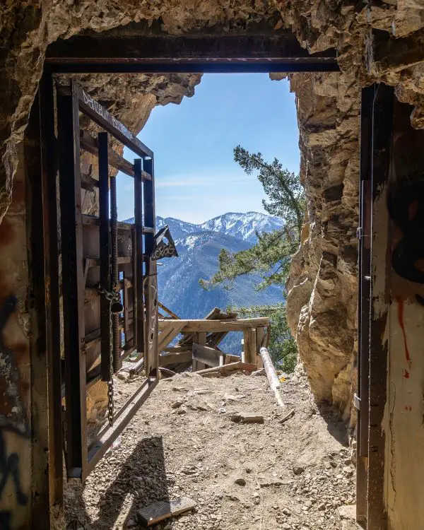
6) Shoemaker Canyon Rd: Nuclear War Escape Tunnels
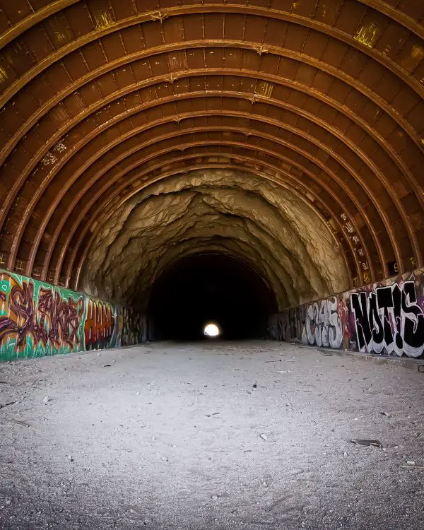
- Total Miles: 5
- Elevation Gain: 1404 Ft
- Map, Directions, & Full Post: Shoemaker Canyon Road
During the Cold War, Los Angeles was worried about a nuclear attack from the Soviet Union, and rightfully so.
To prepare for such a doomsday, the city began drilling two tunnels through the mountains with the intention of creating a faster route to Vegas. Unfortunately, the project was too costly and therefore abandoned.
However, like many abandoned structures in the mountains, these tunnels located near the popular Bridge to Nowhere, have become iconic hikes.
Shoemaker Canyon Road is a dirt road that begins in the East Fork of Azusa Canyon right above the famous prospecting river, San Gabriel. From the road, I could also see amazing views of Mount Bald towering above and Heaton Flats down below.
Fun Fact: I found two bonus water drainage tunnels that can easily be explored and offer unique views. Check out the full post to learn more.
The second tunnel marks the end of the journey for most. However, the road transitions into a single track and continues upward onto Rattlesnake Peak, for those seeking a more challenging destination.
In my opinion, the East Fork has some of the most concentrated and rich history of the Angeles National Forest. Abandoned projects, mines, and hidden gems are located here. Shoemaker Canyon Road is undoubtedly, a special part of this history.
5) Lewis Falls & 2nd Falls No One Knows About
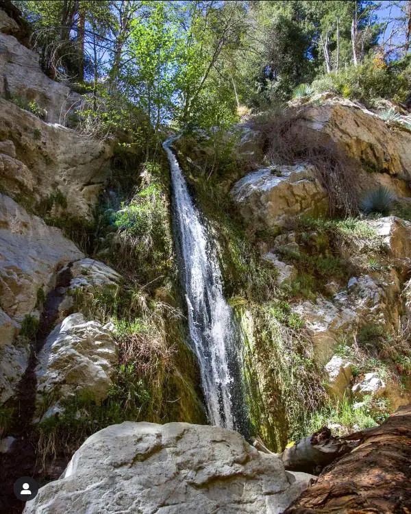
- Total Miles: 0.73
- Elevation Gain: 328 Ft
- Map, Directions, & Full Post: Lewis Falls
Lewis Falls is a beautiful 50-foot cascade in the North Fork of the San Gabriel Canyon. The short trail is very shaded thanks to the abundant plant life, especially the enormous red cedar pine trees that tower over everything in the canyon.
Fun Fact: There’s another hidden waterfall about halfway through the hike which most people miss because it can’t be seen from the trail. You can find out how to get there by checking out the full post.
This is hands down one of my favorite go-to trails because it makes me feel like I’ve left California when in reality I’m still very close to the suburbs of LA where I currently live.
Lewis Falls reminds me a lot of Millard Canyon Falls, but deeper in the mountains, and therefore, slightly more secluded.
Another benefit of Lewis Falls is the fact that it flows almost year long. Most waterfalls dry up sometime during the summer, but I’ve seen Lewis Falls flow late into the fall and sometimes winter.
4) Echo Mt Ruins: Most Popular Trail In LA
- Total Miles: 6
- Elevation Gain: 1566 Ft
- Map, Directions, & Full Post: Echo Mountain
The ruins on Echo Mountain hold, in my opinion, the most interesting and forgotten stories of the San Gabriel Mountains. In a nutshell, an ingenious man by the name of Professor Thaddeus Lowe built a resort called the Echo Mountain House where the ruins are currently located.
He also built a cable funicular railway known as the Great Incline, the Mt Lowe Railway which began at Echo Mt and ended at Ye Alpine Tavern, the Mt Lowe Observatory, zoo, casino, dance hall, and tennis courts.
The hike begins at the Cobb Estate in what is popularly known as the Haunted Forest and leads hikers up the sunny slopes of Echo Mt until arriving at the ruins. Once at the top I explored the ruins of the powerhouse, observatory, and Echo Mt House, and yelled into the Echo Phones which dubbed the mountain its name.
Did I mention I found a secret waterfall across the canyon? You can see those pictures by clicking on the full post above.
3) Sturtevant Falls
- Total Miles: 3.3
- Elevation Gain: 708 Ft
Santa Anita Canyon is very near and dear to me as it was the first place I’ve ever hiked in. The luscious canyon is home to a jaw-dropping cascade that roars over a fifty-foot cliff.
The entire trail is adorned with a wide variety of plant life ranging from Western Sycamores, White Alders, and ferns.
There are also many private cabins located throughout the canyon, many of which are covered with ivy. Ivy seems to be more prevalent in this canyon, making the canyon look more scenic.
The Bobcat Fire of 2020 damaged much of the surrounding landscape but thankfully the waterfall is now open to the public. Just keep in mind Hermit Falls is still closed.
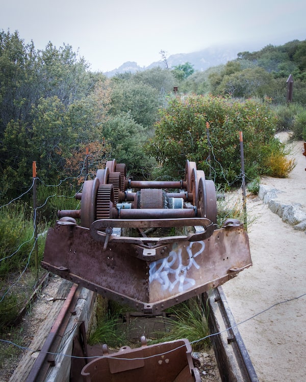
2) Big Horn Mine: Abandoned Gold Mine
- Total Miles: 4
- Elevation Gain: 587 Ft
- Map, Directions, & Full Post: Big Horn Mine
As a result of the 1800’s Gold Rush, the Angeles National Forest is home to over 300 mines. Most of them have been long forgotten, but a few, including the Big Horn, have re-emerged as an adventurous hiking destination.
The Big Horn Mine was founded by Charles Tom Vincent in 1895 while he was out hunting for Big Horn Sheep.
Fun Fact: Both the structures at the mine and his cabin are still standing! Check out the full post to learn how to get to the cabin.
Because the hike begins at a high elevation, giant pine trees crowd the trail. Also, the dirt here is very red, something you rarely see in the Angeles Forest.
The Big Horn Mine is the biggest mine I’ve explored. After going through the portal and walking in about 50 feet, the size of the adit significantly increases and splits off in various directions.
I suggest turning off all your lights for a bit as you stand in place, but don’t walk in the dark! Notice how dark it gets and how the only sound is that of droplets falling from the ceiling. It’s truly a unique experience.
Keep a close eye on the path a few steps ahead as there are huge shafts scattered throughout the place. I used my flashlight to light up the inside of one of the shafts, but it was so deep that we couldn’t see the bottom.
If you’re looking for a one-of-a-kind adventure, I highly suggest the Big Horn Mine. You won’t regret it!
In case you’re wondering, yes there’s still gold in our mountains. It’s legal to pan for gold, but you can’t use any type of machinery or a pickaxe.
1) The Bridge To Nowhere: SoCal’s Largest Ruins
- Total Miles: 9.5
- Elevation Gain: 1246 Ft
Deep in the East Fork of the San Gabriel River, a large bridge towers over the glimmering water. There are no other roads, no vehicles, nor any sign of the city for miles.
That’s because nearly a century ago, citizens of Los Angeles commenced a project to connect the San Gabriel Valley with the little mountain town of Wrightwood, but due to major floods, the landscape completely changed and the roads leading up to the bridge were destroyed. Thus, causing the end of the bridge’s construction.
However, today the Bridge To Nowhere has become one of the most famous hikes to abandoned ruins in Los Angeles, second only to the Echo Mt Ruins. The trail is virtually flat and extremely scenic, especially the section called “The Narrows,” named after a section of the canyon that gets very narrow.
If you’re lucky, you might even spot a herd of Big Horn sheep!
Fun Fact: Bungee America now owns the bridge, where they host bungee jumping days for the public.
FAQs
What Is The Most Popular Trail In Los Angeles?
The most popular trail in all of Los Angeles County is the Echo Mt Ruins, as it has the most All Trail reviews.
What Is The Most Popular Waterfall In LA?
Eaton Canyon Falls is the undisputed champion of LA waterfalls.
Where Do People Go Hiking In LA?
People in LA can choose from many different places to hike including:
- San Gabriel Mts
- Santa Monica Mts
- Regional Parks
- Reserves
- Preserves
- Wilderness Parks
- Large Municipal Parks (i.e. Griffith Park)
- Beaches
Does LA Have Good Hiking?
LA is one of six biodiversity hotspots, meaning it ranks in the top six locations in the world for containing the most plant and animal diversity. Therefore, LA has amazing hikes in mountainous, coastal, desert, and urban regions that vastly differ.
Is Hiking Popular In LA?
Hiking in LA is so popular that even my friends from Colorado make fun of Los Angelinos for always talking about hiking (and tacos).


