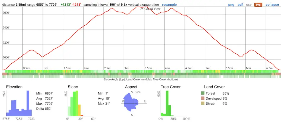
- Total Miles: 6.89
- Time: 3.5 hrs
- Difficulty: Moderate
- Best Season: All Year
- Elevation Gain: 1213 ft
- Max Elevation: 7709 ft
- Type of Trail: Out & Back
- Parking Lot: Fits ≈ 10 cars
- Dogs: Allowed On A Leash
- Restrooms: Available On The Trail
- Trail Popularity: High
- Pics Taken On: Oct 29, 2023
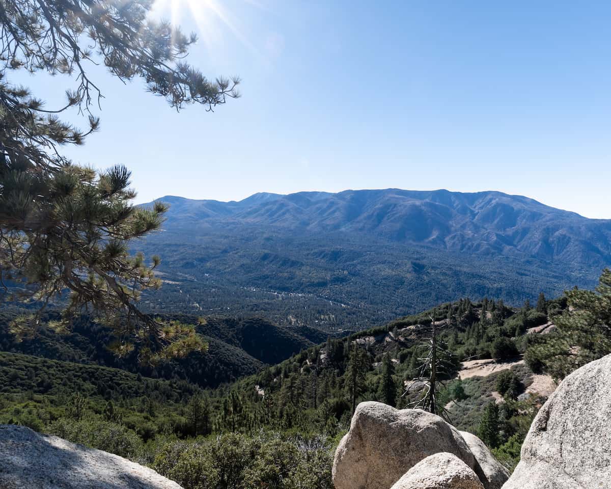
Pine Knot Trail to Grand View Point has become my favorite Big Bear hike for multiple reasons. It’s scenic, especially during the fall when many trees are vibrant orange and yellow, easy enough for most people, and the views from the top which overlooks Hwy 330 and the tallest peak in SoCal, San Gorgonio, are breathtaking, to say the least.
Pine Knot Trail isn’t the only stunning hike in Big Bear, however, so if you want to check out all the best trails in the area be sure to click the link below:
Pine Knot To Grand View Point Trail Map
Address & Directions
To be redirected to the trailhead via Google Maps, click the following link: Aspen Glen Picnic Area
Although the picnic area parking lot only fits about 10 cars, you can park on Mill Creek Rd. Just make sure to keep an eye out for signs on the side of the road that mark the end of street parking. My friend and I got a ticket for parking past an orange cone.
Helpful Links
(Temperatures may significantly drop at Grand View Point )
SoCal Adventure Pass (required to park in SoCal mountains)
Big Bear Weather And More (My friend’s YouTube channel. He updates us on all things Big Bear within a few hours of the event, including weather changes).
Lastly, if you’re hiking shortly after Big Bear gets snow, crampons will be crucial. You can find the ones we use by clicking right here.
Hiking Pine Knot To Grand View Point
The hike began at the Aspen Glen Picnic Area, a large flats boasting many tall pine trees in what seems like all directions. The sunset in the fall here looks nothing short of amazing, as you’ll see later in this post.
Fun Fact: Aspen Glen Picnic Area is very popular during the winter time as it’s more than ideal for sledding (now you know how to save on tubing). You can purchase a sled from the Big 5 or Vons, both of which are located off of Big Bear Blvd.
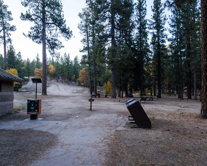
The trailhead was just further up the picnic area. Now, something to keep in mind is the seemingly many trails in all directions, especially at the beginning of the hike.
If you notice logs laid across on what looks to be a trail, it’s probably not a trail.

Here’s an example of what I’m talking about. The image below shows the very first fork.

Shortly afterward, I arrived at another fork. This one is more tricky. Be sure to take the trail to the left.

The trail’s best feature is the bright orange and yellow fall colors. When the breeze blows, many leaves fall from the surrounding trees and make the place look like something out of a movie.
If you’re looking for a similar, woodsy-type hike that is child-friendly, check out Big Bear’s Interpretive Trail on the other side of the lake. It’s easy, fun, and safe for the entire family. Plus, it comes with a PDF guide to teach your kids about Big Bear’s great outdoors.

The brightest trees were just around the bend shown below, so get those cameras ready and pray for a little wind because it’ll be well worth it.

See what I mean? These Western sycamore trees made my day.
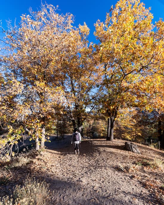
We visited early in the morning, which is why a lot of the sections of the trail could have looked a bit nicer had they been illuminated during the day.
If you don’t mind a bit of sunlight while you hike, plan your visit a little later in the afternoon and you’ll see what I mean. However, expect more people.

Benches are located throughout the hike should you need a break. Unfortunately, the bench below was positioned to face a tree that blocked the view. I’m guessing it was placed there when the tree was much smaller, so we just kept it moving.


I caught a few glimpses of the lake in the first half of the hike.


The following section is probably the most scenic. I could see and hear the creek running on the right side of the trail, and seemingly out of nowhere, I came across a small fern grove.

Thousands of bright orange ferns decorated the landscape and looked almost crystallized for the winter. On my previous visit, I passed by the ferns during sunset. I’ll never forget how amazing they looked.

To my surprise, I noticed off-road vehicles roaming around the forest. I hadn’t realized that dirt roads are accessible to the public. More on this a little later.
Make sure to continue on the dirt trail when you arrive at the dirt road shown below.

After crossing the road, we quickly arrived at Deer Campground. Unfortunately, I couldn’t take pictures of the campground as people were camping and I didn’t want to be disrespectful. You can see the smoke from their fire in the image below.
Bathrooms are located at the campsite. I can’t promise you they’re accessible, but they’re there for sure.

As soon as I passed the campground, I crossed an additional dirt road and continued forward onto Grand View Point.

The forest changes a bit from the campsite onward. It seemed to have opened up a bit more. Instead of climbing up a steep hillside, I traversed a densely forested flat.

And I finally arrived at the last stretch of the trail.
Fun Fact: You can drive your vehicle up to this point and park in the turnout shown below, then hike the last section up to Grand View Point, which is only 0.3 miles. Just keep in mind the roads are closed when it snows, and possibly all of winter.

The two pine trees signify the goalpost. Once you walk through them you’ve arrived at the destination.

The views were well worth it. I took a short break at the picnic bench but didn’t waste too much time as there was one last thing to explore.

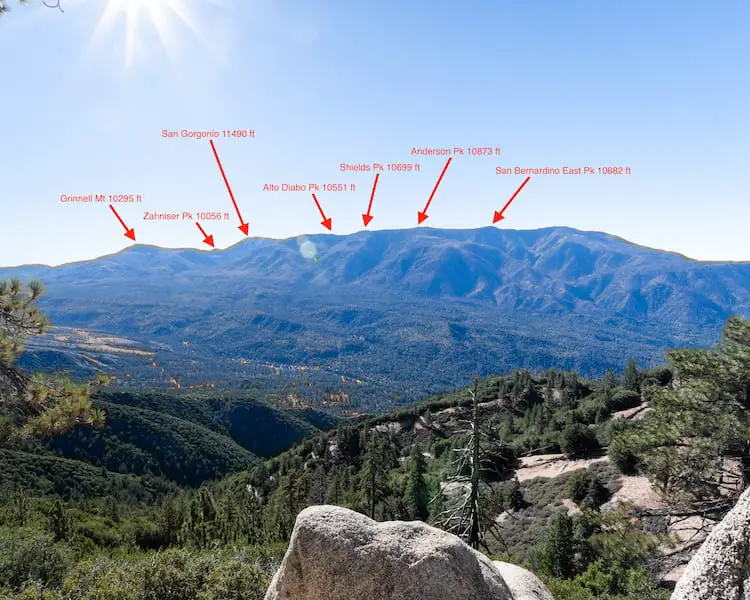
I followed the red arrows in the images and arrived at a small rocky ledge facing San Gorgonio and the Santa Ana River in the valley below.

This is what the ledge looked like but watch your step. It’s slippery.

The hike’s best views were from this ledge—no doubt about it.

I labeled the peaks according to their height. San Gorgonio, also known as Old Greyback, is the tallest peak, not just in San Bernardino but all of Southern California.
Then I walked back up to the bench and got ready to launch the drone.

From the air I could clearly see Santiago and Modjeska peaks, collectively known as Old Saddleback, peeking above the clouds. Pun intended.

To the east, the two sugar mountains loomed high above the valley. I can’t even imagine how amazing the views must be after a good snow dump!

Lastly, to the north, I could see Big Bear Lake and Bertha Peak towering above.
By the way, another amazing Big Bear hike that I highly recommend is Cougar Crest, which takes you up to Bertha Peak’s west ridge, and offers the best lake views in the area.

After enjoying the views, I made my way back the same way and relaxed a little at the picnic area which was now vastly more illuminated by the afternoon sun.

Want to keep exploring Big Bear? Check out Castle Rock, a short 1.44-mile hike to an enormous boulder structure that resembles a building and can be climbed to the top for some amazing lake views.

