California
Hiking Adventures
Adventure Awaits

They Tried To
Erase Us…
107,000 strong on Instagram. 18,000 on Threads. All permanently wiped out overnight due to setbacks beyond my control. Even after taking META to court, the judge ruled in their favor. But I’m not giving up. This time, I’m building something even bigger—on YouTube.
If you’re hungry for adventure, tap the button below and join me in the greatest comeback you’ve ever seen.
Most Popular Trails
30 Fun Winter/Snow Hikes In Southern California: By County
What's up guys. Since we got a really good dump a few weeks ago, I compiled a list of many, but certainly not all, SoCal hikes which get snow almost every year. If you plan on getting out there, remember to always check the weather forecast before stepping on the...
11 Best Hikes For Kids In Los Angeles: Fun & Safe!
Get your kids to fall in love with the outdoors by tackling one of the easy hikes listed below. After digging through my website for the most kid-friendly hikes in Los Angeles, I came up with eleven trails that are primarily safe, but also easy and fun, so that you...

9 Best Los Angeles Hikes For Dogs: Not Your Typical Trails
I remember the first time I hiked with my dogs, Macy, a Pitbull and German Shepherd mix shown in this post's featured image, and Mina, an enormous full-breed German Shepherd. I felt like I was walking in the mountains with two bodyguards, but I also seemed more...
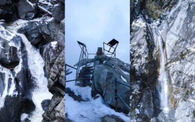
12 Best Waterfalls I’ve Hiked In Los Angeles: 2026 Update
Contrary to popular belief LA is not only a dry concrete jungle. Every spring I see dozens of waterfalls come back to life, incentivizing thousands of Los Angelinos to trade the usual screen time for their hiking boots and some fresh air. I grew up and still live very...
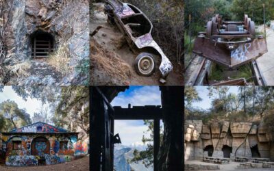
10 Spooky SoCal Hikes Plus Bonus Haunted Places
Just because summer is over doesn't mean you have to stop hiking. Simply hit the trails that fit in with the season, such as the following ten spooky hikes. These trails include various abandoned ruins, many of which hold very dark secrets, while others gave me eerie...
17 Best SoCal Hikes For Kids: Safe, Easy, & Fun Trails
Not all trails are steep, sun exposed, backpack-lugging adventures. In fact, a huge portion of them are the complete opposite, and therefore, suitable for small children. I browsed through my entire website to put together a list of the most kid-friendly hikes in...
11 Best Waterfall Hikes in Southern California: 2026 Update
Looking for breathtaking waterfalls in Southern California? After 15 years of exploring our local mountains, I'd be more than happy to share with you what I think are the11 most awe inspiring cascades, many of which are also the largest in Socal. All of the following...
26 Best Hikes in Southern California: Caves & 500 Ft Falls
Looking for abandoned creepy places, breathtaking views, and stunning waterfalls? Say no more. I browsed through my entire site and chose the trails which I believe are the most breathtaking, jaw-dropping, hikes that'll leave you thinking, "How is this located in...
11 Best Hikes In Los Angeles: Not Found Anywhere Else
Los Angelinos have been in love with hiking since the late 1800s. With the never-ending list of trails growing each year since the hiking boom at the turn of the 20th century, finding the best hiking trails in Los Angeles can be daunting. But not to worry, I'm here to...
Recent Hikes

Santa Ynez Falls: Wading, Scrambling & Off-Trail Thrills (Closed)
Total Miles: 2.27 Time: 1 Hr Difficulty: Moderate Best Season: Spring Elevation Gain: 206 ft Max Elevation: 798 ft Type of Trail: Out & Back Parking: Street Parking Dogs: Not Allowed Restrooms: Not Available Trail Popularity: High Pics Taken On: Feb 8, 2024 Santa...

Escondido Falls: Malibu’s Best Hike
Total Miles: 3.49 Time: 1.5 Hrs Difficulty: Easy Best Season: Spring Elevation Gain: 507 ft Max Elevation: 328 ft Type of Trail: Out & Back Parking: Lot Fits ≈ 15 cars Dogs: Allowed On A Leash Restrooms: 1 Porta Potty At The Parking Lot Trail Popularity: Extremely...

Ferndell Nature Trail To Griffith Observatory Loop
Total Miles: 2.75 Time: 1-1.5 Hrs Difficulty: Easy – Moderate Best Season: All Year Elevation Gain: 632 ft Max Elevation: 1140 ft Type of Trail: Loop Parking Lot: Street Parking Dogs: Allowed On A Leash Restrooms: Available At The Observatory Trail Popularity: Very...