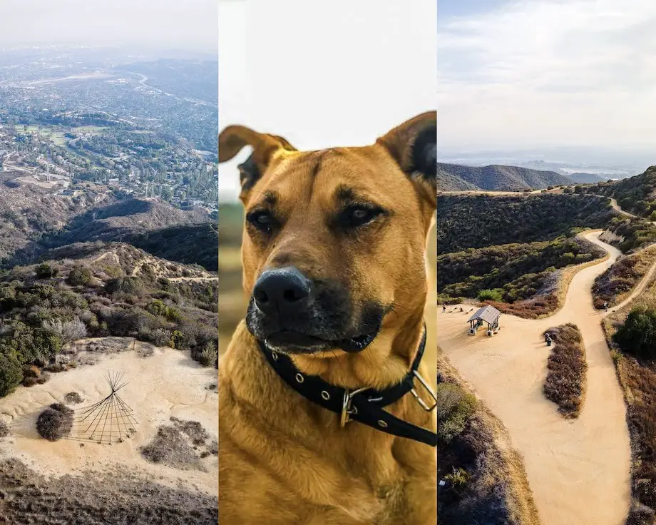
I remember the first time I hiked with my dogs, Macy, a Pitbull and German Shepherd mix shown in this post’s featured image, and Mina, an enormous full-breed German Shepherd. I felt like I was walking in the mountains with two bodyguards, but I also seemed more connected to Mother Nature. Why the latter I can’t explain but it was awesome.
Therefore, I looked through my entire site and put together a list of the most dog-friendly hikes in Los Angeles. Many of these trails are wide to facilitate training your dog for hikes, overgrown vegetation that can contain harmful plants like poison oak or animals such as ticks, and are also less trafficked. I made sure not to include trails that everyone is already familiar with such as Eaton Canyon or the Echo Mt Ruins.
Here they are in no particular order.
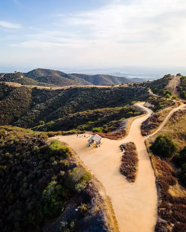
1) Claremont Loop
- Total Miles: 5
- Difficulty: Moderate
- Best Season: All Year
- Elevation Gain: 944 Ft
- Time: 2.5 Hrs
- Dogs: Allowed On A Leash
- Restrooms: Available At The Parking Lot
- Map, Directions, & Full Post: Claremont Loop
The Claremont Loop is a sunny dirt road in, you guessed it, Claremont. The destination on the loop trail can be said to be the viewpoint at the top which allowed me to view the valley below and as far away as the Santa Ana Mountains, While the San Gabriel Mountain ranges towered directly behind me, illuminated by the golden sunset.
The loop’s west side is sunny more than the east so be sure to take a pair of sunglasses, a hat, and plenty of water for you and your dog.
The majority of the area is dry virtually all year except spring. If you can visit during the spring, please do so, you won’t regret it, as the greenery gives the entire area a more appealing look.
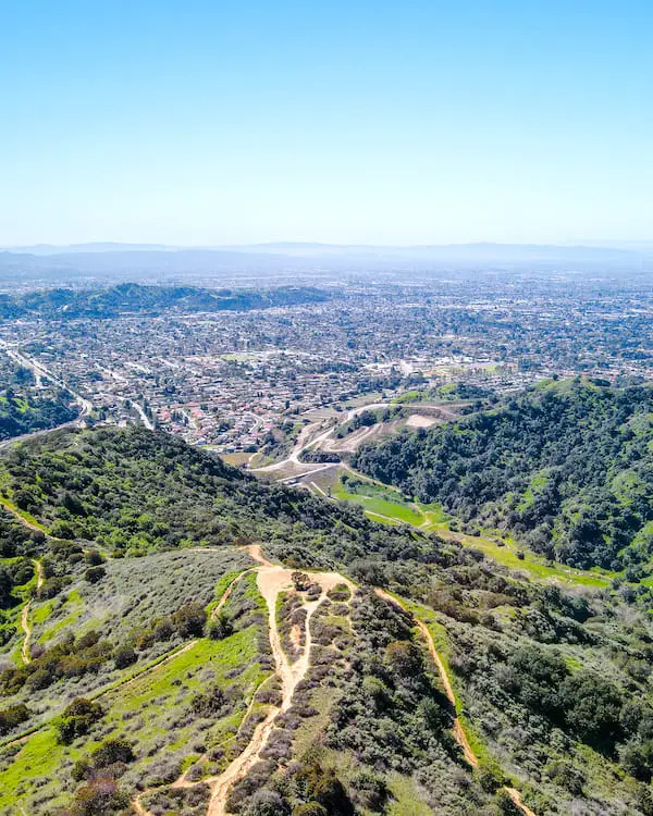
2) Mystic Canyon
- Total Miles: 1.92
- Difficulty: Easy – Moderate
- Best Season: All Year
- Elevation Gain: 707 Ft
- Time: 45 Min
- Dogs: Allowed On A Leash
- Restrooms: Not Available
- Map, Directions, & Full Post: Mystic Canyon Trail
Perhaps the Claremont Loop is too long of a hike? If so, head over to the Mystic Canyon Trail, a short out-and-back hike up to a viewpoint of Glendora and the valley below.
Unlike many hikes in this guide, the trail is a dirt trail and not a dirt road. Almost immediately from the start, the trail gets very steep and loose for a stretch of about fifty feet before reverting to a more gradual ascend.
Unless you have poor balance, you should be fine. Your dog will shouldn’t have a problem ascending the slippery section of the trail, as they’re what I like to call, four-by-four. I’m not kidding, I’ve seen my dogs run up near vertical canyon walls like goats.
Once at the viewpoint I felt surrounded by mountain ranges. I could even see the snow-covered Mt Baldy, the highest peak in the San Gabriel Mts, peeking above the smaller mountains. I visited right after we had major storms, which is why it was so green.
To extend the hike, head up to the Top Of The Punk Out Trail or down to the canyon floor via Lower Monroe Rd, which runs through the viewpoint where the Mystic Canyon Trail ends. Otherwise, head back down the same route.
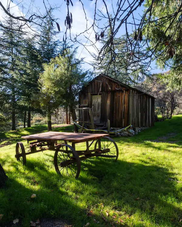
3) Henninger Flats
- Total Miles: 5.04
- Difficulty: Moderate – Hard
- Best Season: All Year
- Elevation Gain: 1531 Ft
- Time: 3 Hrs
- Dogs: Allowed On A Leash
- Restrooms: Available At The Flats
- Map, Directions, & Full Post: Henninger Flats
Henninger Flats is a beautiful hanging basin in Pasadena, CA that has been used for the reforestation of mountains around the world since the days of Theodore Parker Lukens, Pasadena’s former mayor and one of the most important figures in the history of SoCal’s mountains.
I started the hike by descending onto the Eaton Wash, which, since we hadn’t experienced the massive storms of early 2023, was dry except for the small creek.
The majority of the trail is sun-exposed, and, due to the elevation gain, can feel like a workout. If your dog is old, has a medical condition, or simply hasn’t hiked in a long time, you may want to consider a different trail.
The picnic tables at the grassy flats are shaded by abundant pine trees. I also noticed a mountain museum, historical relics scattered such as cabins and prior fire lookouts, restrooms, and a much-needed water fountain.
From the flats, I was able to see the valley below and as far away as Palos Verdes and the glistening Pacific Ocean.
If you want to extend the hike, you can always continue heading up the Mt Wilson Toll Rd.
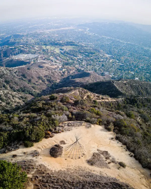
4) La Canada Teepee Trail
- Total Miles: 4.63
- Difficulty: Moderate
- Best Season: All Year
- Elevation Gain: 1003 Ft
- Time: 2.5 Hrs
- Dogs: Allowed On A Leash
- Restrooms: Not Available
- Map, Directions, & Full Post: La Canada Teepee Trail
Like Henninger Flats, La Canada Teepee Trail also ends at a flat where a teepee frame, rock labyrinth, bee farm, and lavender field can be found. Since the flats are private property, we must be very respectful by keeping our dogs leashed at all times.
The hike began at the Angeles Crest Fire Station and took me up to the teepee via the Mt Lukens Truck Trail, a wide dirt road with virtually no shade.
Once I arrived at the teepee, I could see the majority, if not all, of the San Gabriel Valley, and all the way to the ocean.
This trail is also very sunny, so be sure to plan accordingly.
5) Shoemaker Canyon Road
- Total Miles: 5.1
- Difficulty: Moderate
- Best Season: All Year
- Elevation Gain: 1267 Ft
- Time: 2.5 Hrs
- Dogs: Allowed On A Leash
- Restrooms: Not Available
- Map, Directions, & Full Post: Shoemaker Canyon Road
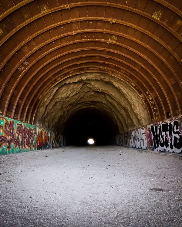
During the Cold War, Los Angeles residents began building tunnels in the East Fork of the San Gabriel Canyon to facilitate the evacuation of the city should a nuclear holocaust begin. However, after budget problems and conservationist efforts, the project was abandoned, leaving two random tunnels seemingly in the middle of nowhere.
The tunnels have now become a popular destination among locals who hike to the tunnels via the dirt Shoemaker Rd. If you’re training a pup to learn how to behave while on a leash, this may be the most ideal place.
The road is very wide, allowing you to easily avoid contact with other dogs or people, and there are no sections of the trail that are overgrown. The downside is the lack of shade. The inside of the two tunnels are the only shaded sections of the trail, so don’t forget sunscreen, a hat, and plenty of water for you and your dog.
Lastly, a viewpoint at the parking lot overlooked the San Gabriel River below.
6) Paramount Ranch
- Total Miles: 2.53
- Difficulty: Easy
- Best Season: All Year
- Elevation Gain: 272 Ft
- Time: 1.5 Hrs
- Dogs: Allowed On A Leash
- Restrooms: Not Available
- Map, Directions, & Full Post: Paramount Ranch Loop
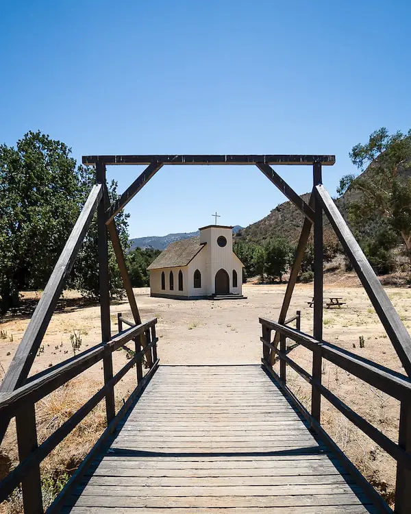
Paramount Ranch is a famous studio set that has been used in countless Hollywood movies like American Sniper and The Great Outdoors. Unfortunately, in 2018 the Woolsey Fire burned down all the structures except the church and train station, but it’s still worth a visit!
The church and train station are located at the trailhead, so there is no need to hike to the set. The loop begins next to the train station for a total of 2.1 miles, but since there are so many trails in the area, you can easily shorten or extend the loop’s distance.
This hike is not on a dirt road but on a dirt trail. Although it looks very remote and scarce of wildlife, a coyote popped up right in front of my truck at the dirt parking lot the last time I visited. Hence, keep your dogs close, especially the small ones, as they can fall prey to a hungry coyote.
There is no shade on this trail, so plan accordingly.
7) Vanalden Cave
- Total Miles: 2.65
- Difficulty: Easy
- Best Season: All Year
- Elevation Gain: 510 Ft
- Time: 1.5 Hrs
- Dogs: Allowed On A Leash
- Restrooms: Available At The Parking Lot
- Map, Directions, & Full Post: Vanalden Cave
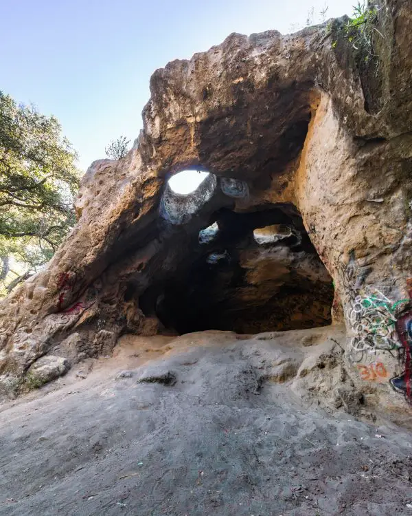
It’s hard to believe caves exist in LA County, but it’s true. The Vanalden Cave is a roughly 25-foot-high sandstone cave in the Santa Monica Mountains.
Almost from the start of the hike, I found myself surrounded by breathtaking views. To the north, I could easily see most of the valley with the Angeles and San Bernardino Mountains towering in the background. To the south, the rest of the Santa Monica Mountains led the eye to the ocean.
For the last part of the hike, I descended to the canyon floor on a dirt trail. The setting quickly transformed from a dry landscape to a luscious woodland, and shortly afterward, reached the Vanalden Cave.
The cave only goes in about 50 feet, but it’s very fun to explore. The inside seems like the perfect place where natives would’ve spent the night while traversing the ranges.
The inside of the cave felt warmer than the air outside. I can only imagine how amazing a campfire would have been.
If you follow a short trail that begins next to the cave, it’ll lead you to the top, just be sure not to fall through one of the holes in the ceiling!
8) Dawn Mine
- Total Miles: 4.66
- Difficulty: Moderate
- Best Season: All Year
- Elevation Gain: 1175 Ft
- Time: 2.5 – 3 Hrs
- Dogs: Allowed On A Leash
- Restrooms: Not Available
- Map, Directions, & Full Post: Dawn Mine Trail
Want to take your dog on an adventure to an abandoned gold mine deep in the San Gabriel Mountains? I bet your dog does.
The Dawn Mine is further up the Millard Canyon from the popular Millard Falls.
The hike began on Mt Lowe Rd but quickly led me onto the canyon floor where the landscape completely changed from dry to full of life, mostly shaded, private cabins, and a flowing stream. Although there are no overgrown sections on the trail, poison oak is nevertheless present in the canyon.
Keep an eye out, and remember, leaves of three let it be.
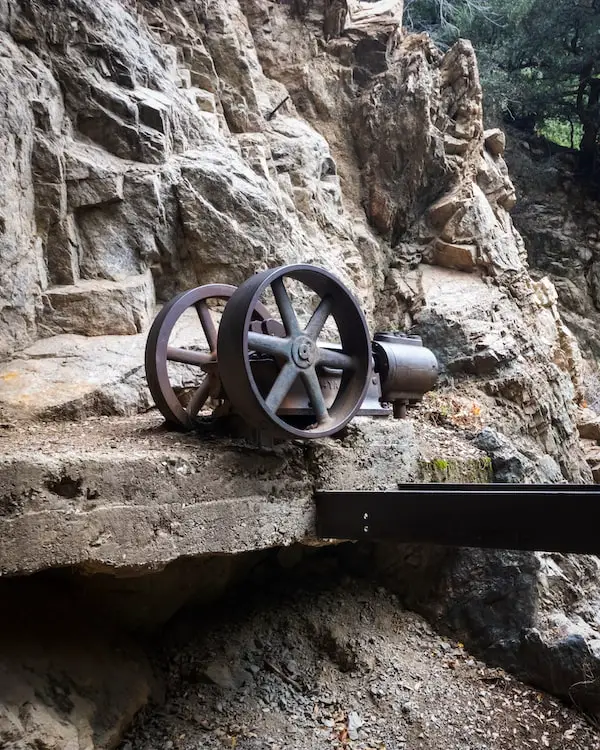
The portal (mine entrance) was a bit difficult to find, but once I spotted the old water pump (in the featured image above), I knew I was at my destination. The portal is located to the left of the water pump, but it’s been closed for quite a few years now.
Water was flowing out of it, and when I shined a light inside, I could see about 50 feet into the adit (mine tunnel).
Fun Fact: If you check out the full post I’ll show you where an additional adit is located, but unlike the Dawn Mine, this portal was open. I was able to explore about 50 feet into the adit until I reached a dead end. Also, unlike most mines I’ve been in, the exploratory dig was very safe.
9) Topanga Lookout
- Total Miles: 2.26
- Difficulty: Easy
- Best Season: All Year
- Elevation Gain: 348 Ft
- Time: 60 Min
- Dogs: Allowed On A Leash
- Restrooms: Not Available
- Map, Directions, & Full Post: Topanga Lookout Trail
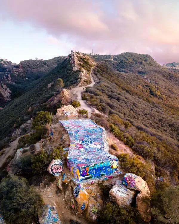
Last but not least on this list is the Topanga Lookout Trail, a hike in the Santa Monica Mts that takes visitors to a concrete ledge with insanely jaw-dropping views.
The ledge was once the foundation for a fire tower but is now a very popular hiking destination that can be accessed via a rutted dirt road. Now, when I say popular, I mean very popular. Expect huge crowds on weekends, so keep that in mind if you or your pooch doesn’t appreciate being around a lot of people.
Since the ledge is elevated above the road and way above the mountain ranges that are directly beneath it, people standing near the edge will get the sensation of flying.
The valley, Angeles, and San Bernardino Mountains can be easily seen on a clear day. Needless to say, sunsets on the lookout are amazing.
Aside from the occasional shrubs on the sides of the road, there is no shade whatsoever. I got the worst sunburn in my entire life the last time I hiked to the lookout.
It’s a short trail, but regardless, plan accordingly, and I hope you have a blast hiking with your dog!

