Looking for breathtaking waterfalls in Southern California? After 15 years of exploring our local mountains, I’d be more than happy to share with you what I think are the11 most awe inspiring cascades, many of which are also the largest in Socal.
All of the following are extremely popular natural waterfalls. If you visit on a weekend make sure to arrive extremely early (7am the latest). Otherwise expect very large crowds.
Generally speaking, the best time to visit any waterfall is from mid spring to early summer. However, the time will slightly vary depending on the amount of water produced by the waterfalls’ springs.
Don’t forget to display your adventure pass when you visit these places, and as always, pack out whatever you pack in! Alright, let’s begin the adventure!
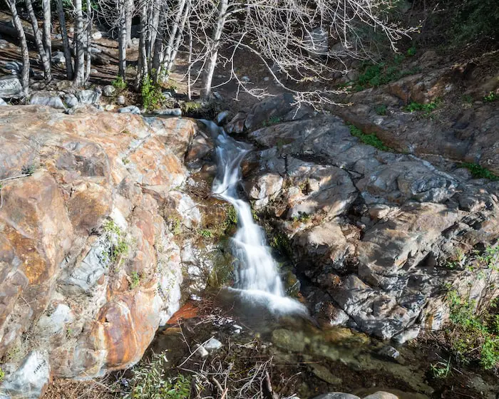
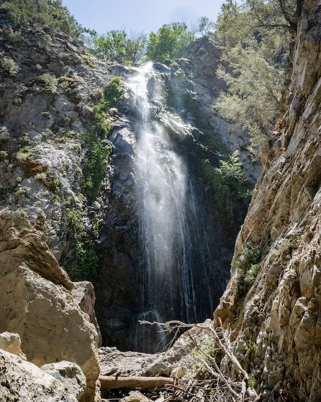
11) Etiwanda Falls: San Bernardino’s Most Popular Waterfall
- Distance: 3.19 miles
- Difficulty: Easy
- Best Season: Spring
- Elevation Gain: 756 ft
- Time: 1.5 Hrs
- Dogs: Not Allowed
- Restrooms: Not Available
- Map, Directions, & Full Post: Etiwanda Falls
Take an easy stroll through North Etiwanda Preserve in the foothills of the San Gabriel Mountains. Although the entirety of the trail consists of a dirt road, the views of the valley and the surrounding mountain ranges make up for the dullness.
There is no shade on this trail until you get to the falls. Fortunately, once I arrived at the falls the abundant White Alders transformed the scenery into a dreamy woodland.
There’s a much smaller waterfall that flows into a round pool located below the main falls, but I don’t recommend climbing down for a closer look as it’s very steep and dangerous.
For those of you who are also history nerds regarding our local mountains, the hike has remnants of the ranching area, when ranchers would tap the water from Etiwanda Creek for their herds.
10) Lewis Falls: Flows Most Of The Year
- Distance: 0.73 miles
- Difficulty: Moderate
- Best Season: Spring – Fall
- Elevation Gain: 328 ft
- Time: 35 min
- Dogs: Allowed On A Leash
- Restrooms: Not Available
- Map, Directions, & Full Post: Lewis Falls
Lewis Falls is a must-do hike for hikers of all experience levels. The trail is mostly shaded and highly vegetated. In fact, one of my favorite things about the hike is the enormous cedar trees, some of which stand at over 100 ft.
Unlike most waterfalls which dry up in early to late summer, Lewis Falls flows almost year-round, from spring to fall. If we get a really wet winter, such as the one we just had in 2023, the falls may flow the entire year.
Bonus Secret Fun Fact: Even cooler than the giant cedar trees is the 20 ft waterfall (shown below) halfway through the hike that goes unnoticed by the vast majority of hikers, and understandably so.
The bonus falls can’t be seen from the trail, and getting to the falls requires climbing down a fallen cedar tree.
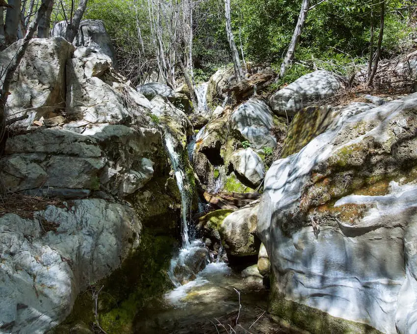
Due to the abundant plant life, the entire hike is extremely scenic. Literally the second I hopped on the trail I felt like I was transported to a different state where the mountainous regions are known for their greenery.
Do yourself a favor, and get out to Lewis Falls.
9) Millard Falls: Scenic Hike In Altadena
- Distance: 1.3 miles
- Difficulty: Easy
- Best Season: Spring
- Elevation Gain: 308 ft
- Time: 45 min
- Dogs: Allowed On A Leash
- Restrooms: Available At The Campground
- Map, Directions, & Full Post: Millard Canyon Falls
Millard Falls is a beautiful 50 ft cascade located in the foothills of the San Gabriel Mts which gets a good amount of water flow every year during spring time. Additionally, the trail is easily one of the most scenic in the Angeles Forest.
The falls boasts white granite rock and vibrant green moss, making it unique among its SoCal contemporaries. The vast majority of the trail is covered by the forest canopy and adorned by Sycamores and White Alders.
The trail’s gradual incline, lots of shade, lack of steep ledges, and rare poison oak sightings makes it an ideal hike for small children and dogs, but be prepared for multiple creek crossings. The crossings are not difficult, however, as they’re very narrow and shallow.
Bonus secret fun fact: The top of the falls can be accessed by climbing up the east side of the canyon wall. However, I don’t recommend doing so unless you’re an experienced climber as it’s very steep.
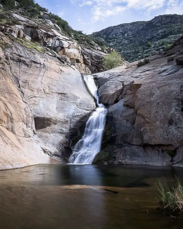
8) Stoddard Canyon Falls: Rockslide And Pool!
- Distance: 0.75 miles
- Difficulty: Easy
- Best Season: Spring
- Elevation Gain: 160 ft
- Time: 35 min
- Dogs: Allowed On A Leash
- Restrooms: Not Available
- Map, Directions, & Full Post: Stoddard Canyon Falls
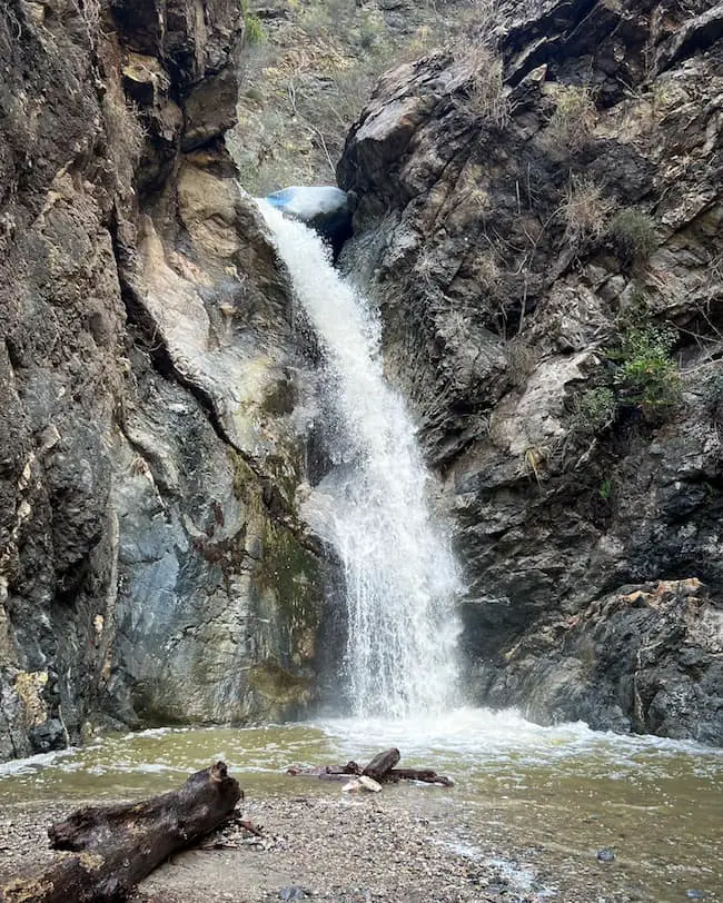
Stoddard Falls is a very easy hike to a 40 ft waterfall in San Antonio Canyon. From the get go one of the first things I noticed was the pristine water in the creek. I’m not kidding, it was crystal clear blue, like that of a chlorinated swimming pool, minus the chlorine of course.
The hike begins on a paved road, then sharply descends the canyon wall via a dirt trail. Once at the canyon floor, I found myself boulder hopping my way up the last section of the trail.
As the title suggests, Stoddard Falls forms a natural rock slide. However, the swimming hole at the base of the falls may only be deep enough during the spring, when water flow increases.
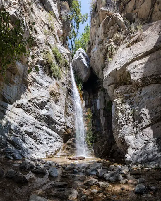
7) Eaton Canyon Falls: The Yosemite of The San Gabriels
- Distance: 4.02 miles
- Difficulty: Easy
- Best Season: Spring
- Elevation Gain: 455 feet
- Time: 2.5 hours
- Dogs: Allowed On A Leash
- Restrooms: Available At The Parking Lot
- Map, Directions, & Full Post: Eaton Canyon Falls
Eaton Canyon Falls is one of the most popular waterfalls in the Angeles National Forest, second only to Etiwanda Falls. It was dubbed the Yosemite of the San Gabriels by John Muir.
This trail actually has 3 trailheads, which you can see on the map. The 1st trailhead is the most popular. It begins at the Nature Center, and requires hiking through most of the Eaton Wash.
The trail follows the creek for the entire hike, which means visitors will have to cross the creek via precariously laid out rocks and logs about 7ish times. Hence, if you don’t have good balance, I highly recommend a good pair of trekking poles. I use these right here.
Although the trail totals over 4 miles, the low elevation gain and partial shade inside the canyon make this a very enjoyable hike.
The trail ends when you arrive at the 40 foot cascade. Unfortunately, the pool is not deep enough to allow for swimming, but getting drenched underneath the falls is highly recommended.
Bonus secret fun fact: Just over the falls and about a 1/4 mile further up the canyon lays a secret waterfall with a big slide and a swimming hole. Reaching it requires rappelling gear.
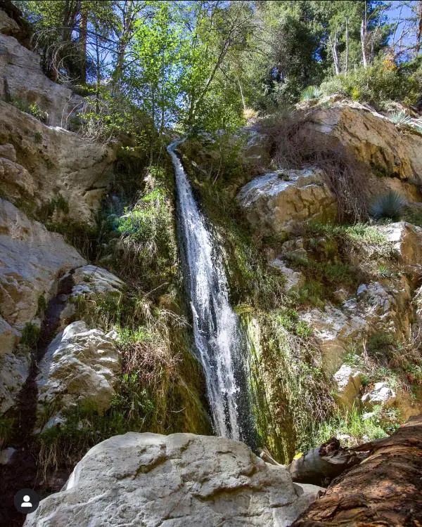
6) San Antonio Falls: Fun Family Hike
- Distance: 1.33 miles
- Difficulty: Easy
- Best Season: Spring
- Elevation Gain: 277 feet
- Time: 30 min
- Dogs: Allowed On A Leash
- Restrooms: Not Available
- Map, Directions, Video, & Full Post: San Antonio Falls
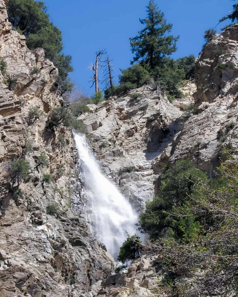
San Antonio Falls is one of the largest in the San Gabriels Mts. Most online guides claim it’s 75 feet high, but I believe that only applies to the bottom tier. I think it’s closer to 200 feet high as can be seen from my drone video in the full post.
The majority of the hike consists of a paved road with amazing views of the luscious green canyon below and the San Gabriel Valley. Towards the end of the hike, the paved road connects to a dirt trail which leads down to the base of the falls.
The elevation at the falls is a whopping 6400 feet, which means, yup you guessed it, winter snow!
There is no shade on this trail, but I highly recommend visiting around 10am-12pm on any given day because that’s when the sunlight illuminates the waterfall and makes San Antonio Falls glisten in all its beauty.
San Antonio Falls is one of the few waterfalls that boasts a decent water flow year round.
Bonus secret fun fact: San Antonio Falls is a multi-tiered waterfall. What most people don’t know is that you can make your way up to the top tiers, one of which has a little pool perfect for cooling off and relaxing!
5) Big Falls: Highest Waterfall In Southern California
- Distance: 0.66 miles
- Difficulty: Easy
- Best Season: Spring – Summer
- Elevation Gain: 174 feet
- Time: 25 min
- Dogs: Allowed On A Leash
- Restrooms: Available At The Parking Lot
- Map, Directions, & Full Post: Big Falls
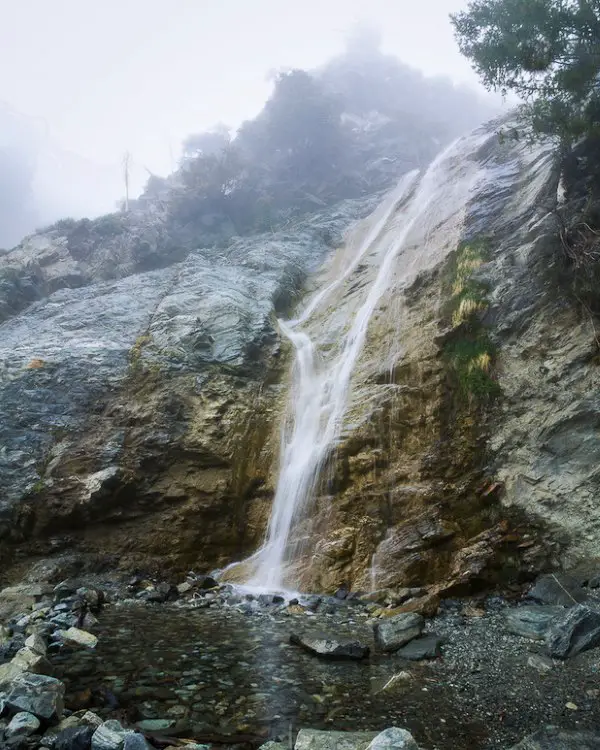
At a height of 500 feet, Big Falls has rightfully earned its name. It’s actually the tallest waterfall in Socal and one of the largest in the state.
This giant consists of five tiers, with the larger tiers making up the top of the falls. The waterfall is so enormous that you can see the top tier as you’re driving up to the parking lot.
The trail ends at the lowest tier, which is about 20 feet tall. You can see the next tier further up the creek from the base of the falls and all the way to the 2nd highest tier. It’s a truly amazing experience.
By the way, the Big Falls parking lot offers both free and paid parking. Free parking is located on the lefthand side of the lot. Otherwise, you can purchase a recreation day pass at the kiosk or Elk General Store.
The hike is mostly shaded and the creek is LITTERED with smaller waterfalls. I have never seen so much water and waterfalls in my life, but that explains why Big Falls has a decent amount of water year round.
Bonus secret fun fact: You can actually make your way up to the second highest tier, but I don’ t recommend it for the faint of heart.
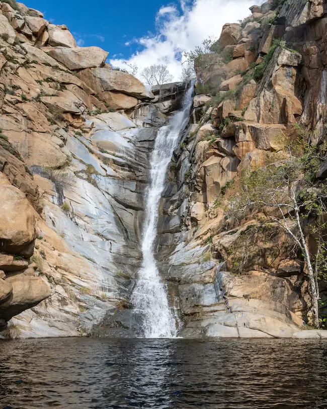
4) Bonita Falls: 2nd Highest Waterfall In SoCal
- Distance: 1.28 miles
- Difficulty: Easy
- Best Season: Spring
- Elevation Gain: 443 ft
- Time: 45 min
- Dogs: Allowed On A Leash
- Restrooms: Available At Bonita Campground
- Map, Directions, & Full Post: Bonita Falls
495 foot Bonita Falls is easily one of the most stunning falls in SoCal, and has more water year round than most waterfalls. Unfortunately, it’s gotten the worst of trash and graffiti.
The trail begins at the Bonita Campground, which charges $10 for parking. If you pay the campground fee, an adventure pass is no longer needed.
Make your way across the canyon, known as South Fork Lytle Creek, and look for any signs of other people’s tracks. The majority of the hike requires trekking through a dry riverbed which consists of mostly rocks and boulders.
However, once you head into the tributary, the environment rapidly transitions into a green paradise. If you manage to arrive at the falls between the hours of 12 and 2pm, Bonita Falls will glisten more beautifully than any other waterfall in SoCal.
Bonus secret fun fact: There’s not one, but TWO secret waterfalls directly above Bonita Falls that most people don’t know about. When you include all three tiers, Bonita Falls measures a whopping 495 feet, making it the second largest falls in SoCal.
However, climbing up to the top two tiers is highly unadvised as many rescues have already taken place. One small mistake can cost you your life.
3) Sturtevant Falls: Arcadia’s Beloved Gem
- Distance: 3.3 miles
- Difficulty: Easy – Moderate
- Elevation Gain: 400 ft
- Time: 1 hr 45 min
- Dogs: Allowed On A Leash
- Restrooms: Available At The Parking Lot
Due to the Bobcat Fire, Sturtevant Falls was closed in September 2020 but has officially reopened and is just as beautiful as before (Hermit Falls further downstream is closed).
At a height of 50 feet, Sturtevant Falls is on the smaller end, but what it lacks in size it clearly makes up for in looks.
The trail begins at Chantry Flats and immediately descends via a steep cemented road with very little shade, which you’ll have to ascend on your way back. The road transitions into a dirt trail once you arrive at the canyon floor.
From this point onward the trail is mostly shaded and surrounded by an abundance of vegetation. Upon arriving at the falls, you’ll notice people taking a trail over the waterfall and continuing their journey into the canyon.
That trail is the Gabrielino trail, and it takes you to Sturtevant Camp then as high as Mount Wilson. However, our journey ends at the base of the falls, with one of the nicest looking cascades in SoCal.
Bonus secret fun fact: Once Sturtevant Falls reopens, so will Hermit Falls, which is located further down the canyon but is connected to Sturtevant Falls.
Hermit Falls is smaller, only 30 ft high, but is very popular with the locals because its swimming hole is deep enough for cliff jumping.
2) Cedar Creek Falls & Devil’s Punchbowl
- Distance: 5.5 miles
- Difficulty: Moderate – Hard
- Best Season: Spring
- Elevation Gain: 1026 ft
- Time: 3 hrs
- Dogs: Allowed On A Leash
- Restrooms: Available At The Parking Lot
- Map, Directions, & Full Post: Cedar Creek Falls
In order to hop on the trail, you must purchase a $6 parking permit in advance, which you can find here. Yes, they do check. They have a sign-in sheet at the trailhead, which also explains why there’s no trash or graffiti on the trail.
Roughly 3/4 of the hike is completely exposed, so plan accordingly. Unlike most hikes, the trail begins by descending onto the canyon floor, then makes its way into a tributary where the giant awaits your presence.
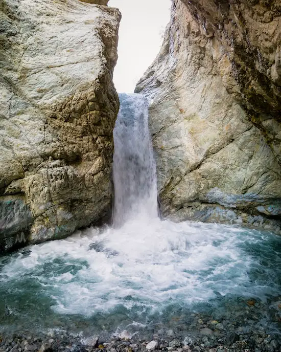
As you get closer, you’ll see the top of the falls towering over everything in the canyon. Cedar Creek, which is arguably the most beautiful waterfall in SoCal, plunges over the side of an 80 foot cliff and into a massive swimming hole known as the Devil’s Punchbowl. Unfortunately, cliff jumping, even from smaller ledges, is prohibited.
While most waterfalls consist of a thin stream free falling off a cliff, Cedar Creek Falls is very wide when it’s flowing, and makes contact with the canyon wall a few times before reaching the pool, which is why it produces a louder roar.
I felt like I was in the presence of a giant, a skyscraper waterfall if you will. Although Bonita falls is an additional 20 ft higher, Cedar Creek Falls gave off a larger and much more powerful presence.
Bonus secret fun fact: There’s a smaller pool at the top of the falls which allows you to lean right on the edge of the cliff and look down at the Devil’s Punchbowl. It’s much less known and the perfect place to relax.
1) Three Sisters Falls: San Diego’s #1 Waterfall
- Distance: 3.39 miles
- Difficulty: Moderate – Hard
- Best Season: Spring
- Elevation Gain: 1069 ft
- Time: 3.5 – 4 hrs
- Dogs: Allowed On A Leash
- Restrooms: Available At The Parking Lot
- Map, Directions, & Full Post: Three Sisters Falls
Based off the number of All Trails reviews, Three Sisters Falls is the most popular waterfall in Southern California, but I’d argue Cedar Creek Falls is the most breathtaking.
Much like Cedar Creek, the trail to the 150 foot Three Sisters Falls also begins by descending, and is mostly exposed to the elements. Hence, pack plenty of water and a hat.
Trash and graffiti is virtually nonexistent, adding to the setting’s beauty.
The waterfall’s name is derived from its three tiers. The top tier stands at about 25-30 feet high. The middle tier, which is the nicest of the three, is a decent 50 feet tall, and the bottom tier is roughly 20 feet high.
The top two tiers contain swimming holes deep enough for cliff jumping.
I think what makes Three Sisters Falls so unique is its resemblance to a river with waterfalls, rather than a waterfall with tiers.
In other words, the waterfall follows a much more gradual descend down the canyon compared to most creeks which plunge off the side of a huge cliff.
Well, if you were looking for hiking trails with waterfalls in Southern California I hope I provided enough of them to keep you busy for a few weeks. Each one of these places has unique things to offer, whether that’s views, pools, or simply a good time.
All that’s left to do is to get out there and create your own California adventure.


