
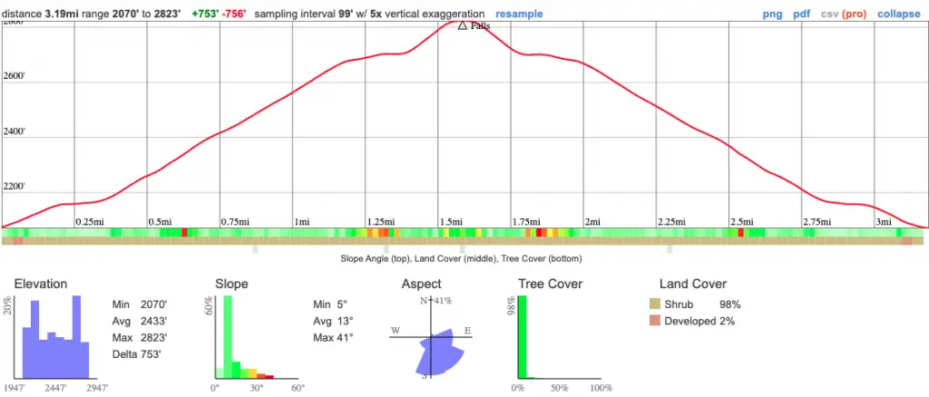
- Miles: 3.19
- Time: 1.5 hrs
- Difficulty: Easy
- Best Season: Spring
- Elevation Gain: 756 ft
- Max Elevation: 2823 ft
- Type of Trail: Out & Back
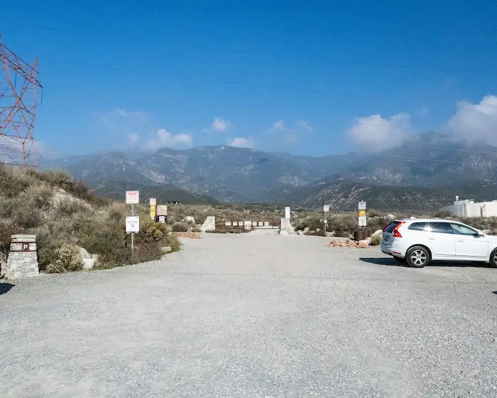
- Parking Lot: Dirt Lot Fits 30+ Cars
- Dogs: Not Allowed
- Restrooms: Not Available
- Trail Popularity: Very High
- Pics Taken On: Nov 30, 2022
According to All Trails, Etiwanda Falls has the most reviews out of any hike in San Bernardino County. So of course, I planned a visit to see what all the fuss was about.
Etiwanda Falls Trail leads to a popular 15-20 ft cascade in North Etiwanda Preserve. The moderately difficult hike primarily consists of a shadeless dirt road surrounded by the well-known chaparral frequently seen in low mountainous elevations. However, upon arriving at the falls, the scenery transforms into a luscious riparian woodland.
I dubbed Etiwanda Falls as one of the must-do waterfalls in Southern California. However, it’s far from being at the top of the list. Check out the link below to view the complete list.
Etiwanda Falls Trail Map
Address & Directions
To be redirected to the trailhead via Google Maps, click the following link: Etiwanda Ave, Rancho Cucamonga, CA 91739
Helpful Links
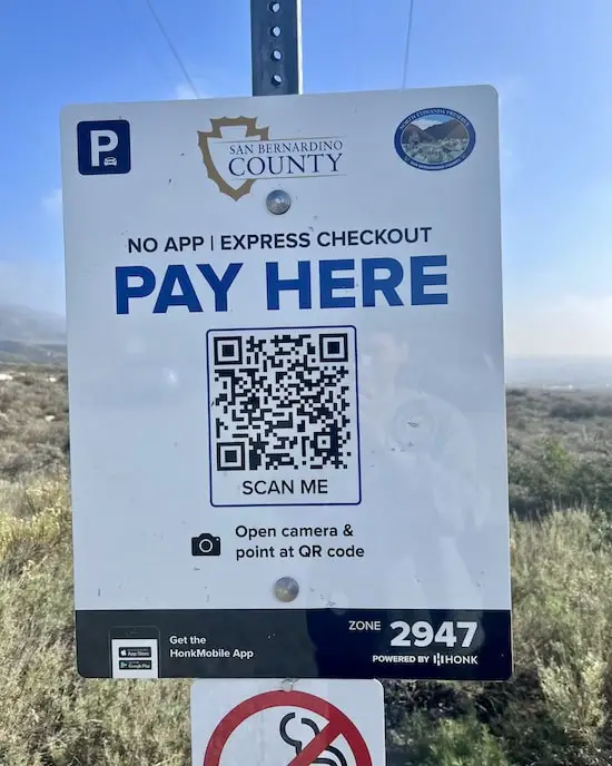
Click one of the following links to download the HonkMobile App on iPhones or Androids to pay for your parking permit, or scan the QR code below.
Expect enormous crowds on the weekends.
**Check the hours below so you don’t get locked inside the parking lot after they close the gate.**
Etiwanda Falls Hours
Summer Months Mar – Oct: 6:30 am – 8:00 pm
Winter Months Nov – Feb 6:30 am – 5:00 pm
Etiwanda Falls Trail
After paying the parking fee, I headed straight through the next gate and towards the mountains.
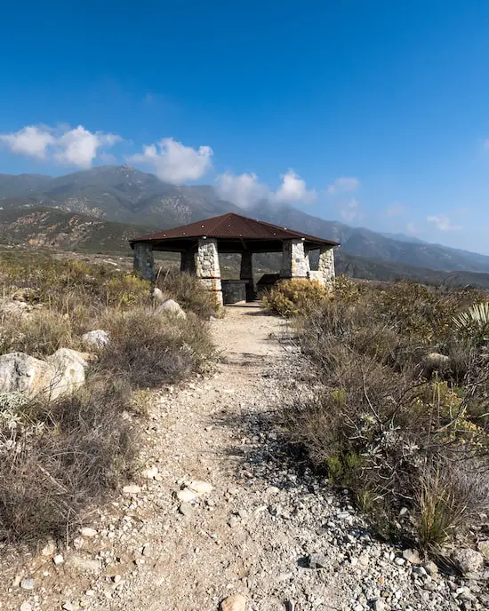
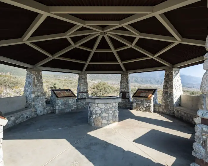
Although not on the map, the pavilion below is easy to spot, and features interesting information regarding the area, its history, endangered species, and plants.
I highly recommend it, as it’s only a 1-minute detour.
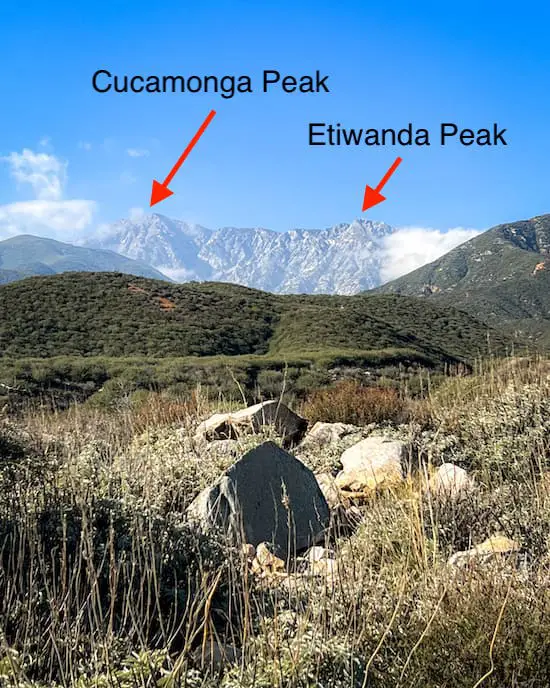
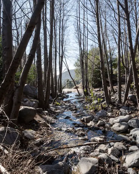
I’ll be completely honest with you. The trail is a not-so-exciting dirt road, but luckily I had an amazing view of the valley to the south, Cucamonga and Etiwanda Peak towering above to the north,
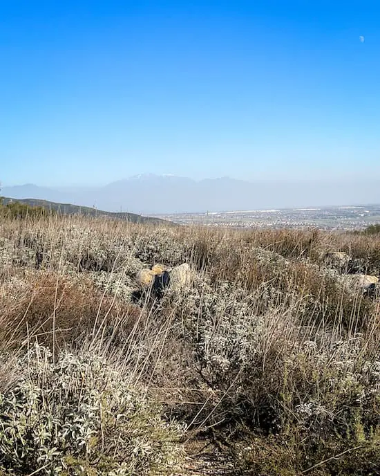
Below, is Old Greyback (San Gorgonio) to the east.
These peaks can be hiked, but they’re not beginner-friendly. If you’re in the mood for peak bagging but prefer a moderately challenging trail, try Sunset Peak or Stoddard Peak. Both are great intermediate hikes located in San Antonio Canyon.
Further up the road, I came across a late 19th century water pipe that once allowed ranchers and farmers to harness the waters of East Etiwanda Creek.
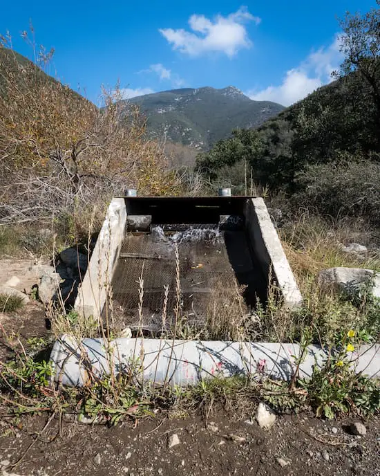
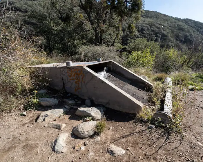
The structure shown below is known as an overflow drain and was used along with water pipes to prevent flooding.
Hopefully, it’s flowing during your visit as it was on mine.
After hiking underneath the merciless sun and on the rutted road, I arrived at mountain paradise.
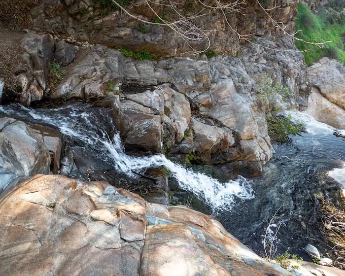
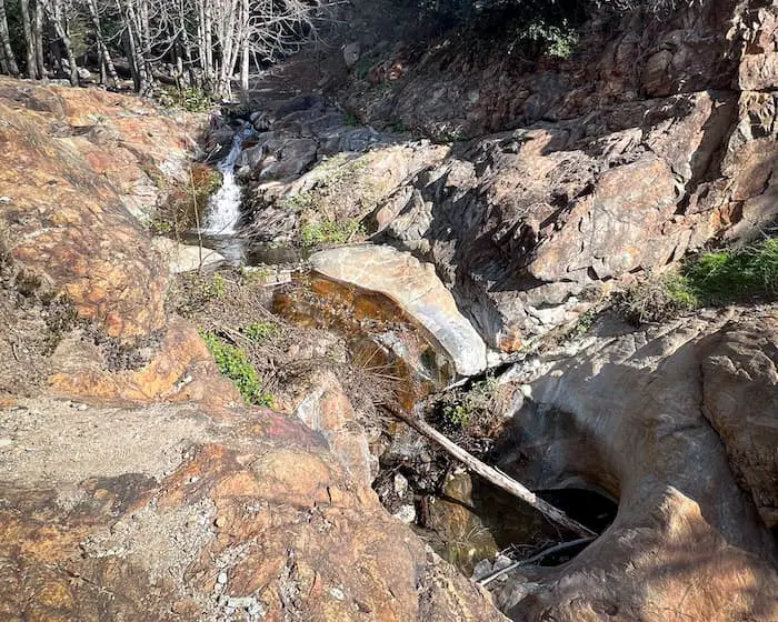
At the top of the falls, I had a stunning view of the East Etiwanda Canyon mouth opening up and the creek gushing over the second much smaller falls.
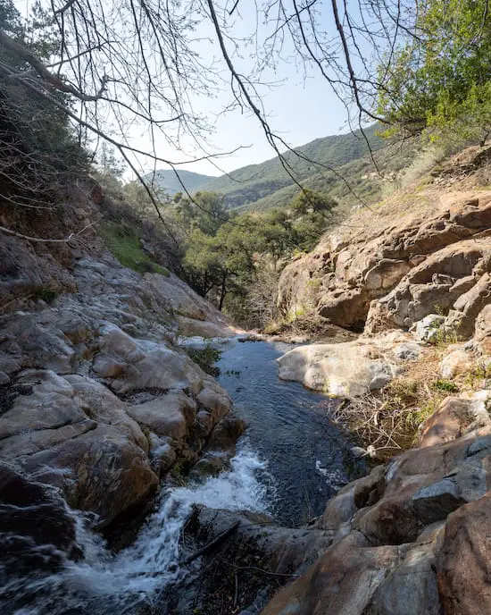
Deeper into the canyon, White Alder trees decorate the landscape, making it look like a wooden scenery normally seen in movies.
You would never think to see a waterfall like this in Rancho Cucamonga.
I’m not sure how Etiwanda Falls is more popular than the biggest waterfall in SoCal, a colossal 500-foot multi-tiered waterfall, or Bonita Falls, the second largest. Both hikes are easier than Etiwanda Falls and the trails are more scenic. Check them out by clicking the link.
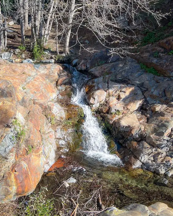
The second much smaller waterfall resembling a slide is located below Etiwanda Falls and directs the creek into a pool. However, I don’t recommend climbing down, as it’s steep and dangerous.
Speaking of slides, you NEED to do yourself a favor and hike to the beautiful Stoddard Falls with a rockslide and pool in San Antonio Canyon. The water is crystal clear and deep enough to swim in.
I was shocked to see this much water flowing in December, especially after a dry season. I guess that just like San Antonio Waterfall near the Mt Baldy area, Etiwanda Falls has become very popular due to its annual flow. The former, however, is much more impressive.

Don’t get me wrong, Etiwanda Waterfall is beautiful, but I must admit, it’s nowhere near as stunning as 25 ft Heart Rock Falls located in Crestline, a forested town deep in the San Bernardinos.
It’s relatively close to Etiwanda Preserve, so you could hike both trails on the same day if you wanted to.
Recommended Gear
- Merrel Moab Hiking Boots (I use the Moab 2 Vent Mid Boot)
- Nalgene Wide Mouth Waterbottle
- Long Sleeve Ventilating Shirt
North Etiwanda Endangered Species
North Etiwanda Preserve is home to a wide variety of animals, but unfortunately, some face the threat of extinction.
The following 10 species have been classified by the US Department of Interior and the State of CA as endangered, threatened, or species of special concern.
Please, always pack out what you pack in.
- San Diego Horned Lizard – special concern
- Mountain Yellow-legged Frog – endangered
- San Diego Ring-necked Snake – special concern
- LA Pocket Mouse – special concern
- San Bernardino Kangaroo Rat – endangered
- Southwestern Willow Flycatcher – endangered
- Bell’s Sage Sparrow – special concern
- Rufous-crowned Sparrow – special concern
- Least Bell’s Vireo – endangered
- Coastal California Gnatcatcher – threatened
Etiwanda Falls Trail Plants
Don’t forget to keep an eye out for these plants while you’re on the trail. Some can be seen year-round, while others are seasonal.
- Chamise
- California Sagebrush
- Bigberry Manzanita
- Plummer’s Mariposa Lily
- Mule Fat
- California Lilac
- Blue Dicks
- Scale Broom
- California Fuchsia
- California Buckwheat
- Stinging Annual Lupine
- Canyon Live Oak
- White Sage
- Our Lord’s Candle (Yucca)
- Poison Oak
- California Wild Grape
- Black Sage
- California Brittlebush
Etiwanda Falls History
In 1882, American settlers named Etiwanda Falls after a native tribe from Lake Michigan.
However, the area originally belonged to two California tribes, the Tongva and the Taaqtam.
The Tongva people were also known as Gabrielinos by the Spanish as they were the closest tribe to the San Gabriel Mission.
The second tribe was the Taaqtam people, also known as Serranos by the Spanish, which means “people of the pines” because they were the more mountaineer type out of all the local tribes.
As is the case with most of our California tribes, the history has been, unfortunately, lost.
Hence, what we know traces back to 1774, when Spanish Captain Juan Bautista de Anza passed through the area to find an overland trail from Mexico to the San Gabriel Mission.
The Spanish, whose primary profession was ranching, were the first Europeans to settle in Southern California. Mexico later won independence from Spain and took over the land, but very little changed.
However, when the US took hold of the fertile land, it was quickly converted into groves, which is why you still see a few fruit groves scattered throughout Riverside and San Bernardino.
Water
The canyons in North Etiwanda Preserve were one of the first to be used for harvesting and transporting water. The water was transported to the valley first via simple ditches and canals dug in the ground, then using wooden flumes.
When the wooden flumes were destroyed by floods or decayed, they were replaced with clay pipes, as they were more effective at minimizing the amount of water lost to evaporation, absorption, or spilling outside of the flumes. You can still see remnants of the clay scattered throughout the trail.
Stone walls, whose remnants can also be seen today, were built to protect the clay pipes and maintain the proper gradient, thus ensuring gravity flow.
Keep an eye out for cylinder-shaped concrete structures. These chambers housed multiple pipe openings to cut the water off to certain pipes while directing the flow to others to facilitate the distribution among fellow ranchers.
The Zanjero, a Spanish word for “ditch master” was responsible for controlling and directing the water to landowners at the appropriate times.
Eventually, clay pipes were replaced by concrete pipes buried underground.
FAQ
Is Etiwanda Falls Stroller Friendly?
Although the Etiwanda Falls Trail consists entirely of a dirt road, it is not stroller-friendly, as is very rutted.
Do You Have To Pay For Parking At Etiwanda Falls?
Paying for a permit is required to park at the Etiwanda Falls trailhead.
How Long Is The Etiwanda Falls Hike?
Etiwanda Falls is a 3.19-mile roundtrip hike.


