
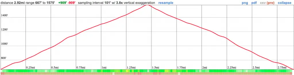
Distance
3 Miles
Time
1.5 Hrs
Difficulty
Moderate
Season
All Year
Elevation Gain
908 Ft
- Dogs allowed on a leash
- Out & Back Trail
- Restrooms Available at The Trailhead
Ready for a quick adventure to a sunny peak in the San Carlos neighborhood? If so, I have just the hike for you.
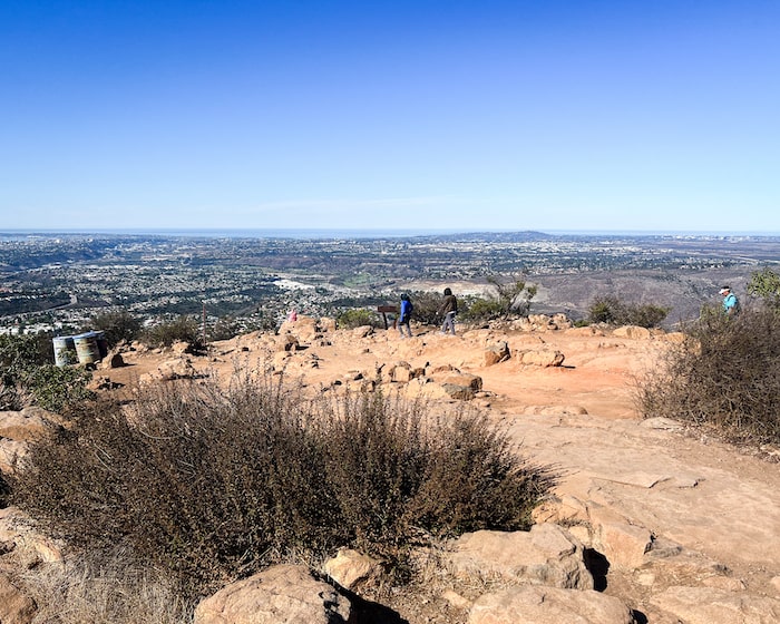
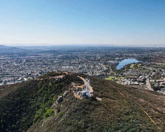
Cowles Mountain in Mission Trails Regional Park is considered the most popular trail in San Diego County, and is also the highest point in the city. It offers amazing 360 panoramic views ranging from Orange County to Mexico, and lake Murray. There is no shade on this trail.
Cowles Mountain Map
Cowles Mountain Directions
Click the link to be redirected to the Cowles Mountain Parking Lot on Google Maps.
Cowles Mt has multiple trailheads, and this one happens to be the most popular. Therefore, expect massive crowds on the weekends.
I went on a Wed at 9:30ish am and it was surprisingly not too heavily trafficked.
If the lot is full, you can park on Golfcrest Dr. right in front of the parking lot, but on the weekends even that too gets full.
More San Diego hikes you’ll love!
- Three Sisters Falls: Best 3-Tier Waterfall in SD
- Torrey Pines Beach Loop Trail: Best Beach Hike in SoCal
- Kitchen Creek Falls: Hike to Natural Pools & Waterfall
Cowles Mountain Trail
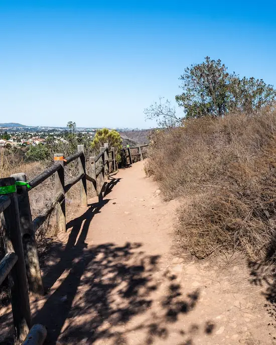
Your journey to Cowles Mt Peak begins on a series of stone steps which quickly convert into a dirt single track.
Remember, there is no shade on this trail so don’t forget your hat and water!

Although it’s hard to see in the image below, the city of San Diego is visible from the trail almost from the very beginning.
As you continue your way up, Cowles Mt Peak looms over the subpeak in the foreground.
Giant boulders decorate the mountainside, giving off that unique look of the Southern end of Cleveland National Forest.
Read More: 11 Best Hikes in Socal

You’ll notice a few trail splits during your trek, but as long as you stay left at every fork, you’ll make it to your destination.
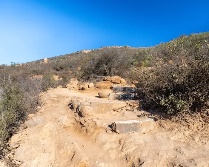
The steps shown below mark the beginning of the switchbacks, which are the last section of the trail before reaching the peak.
After a quick and pleasant trek up the mountain, you’ve reached the summit marker, and the highest point in the city of San Diego.
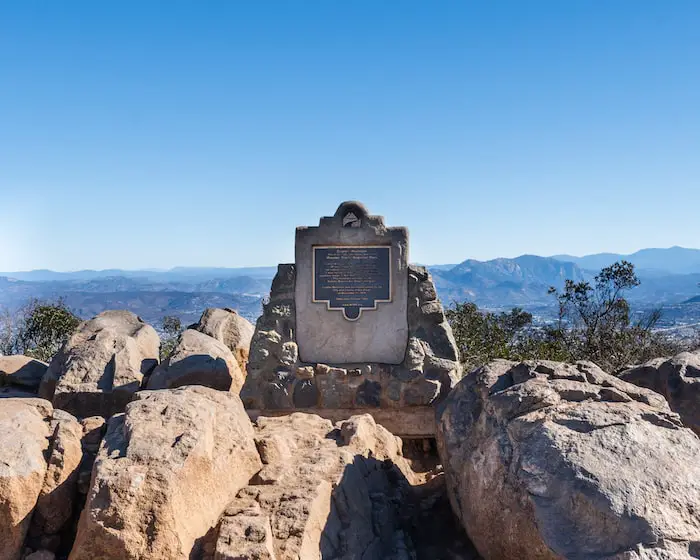
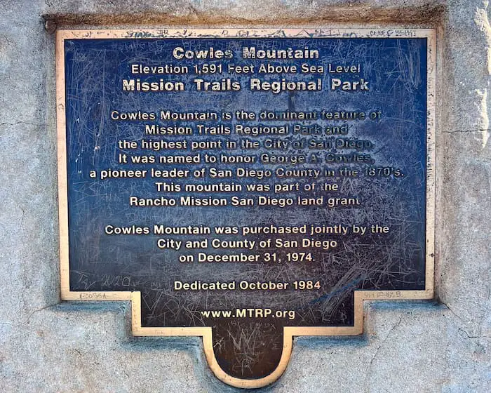
In case the text on the marker is too small to read, here is what it says:
Cowles Mountain
Elevation 1,591 Feet Above Sea Level
Mission Trails Regional Park
Cowles Mountain is the dominant feature of Mission Trails Regional Park and the highest point in the city of San Diego. It was named to honor George A Cowles, a pioneer leader of San Diego County in the 1870’s. This mountain was part of the Rancho Mission San Diego land grant.
Cowles Mountain was purchased jointly by the City and County of San Diego on December 31, 1974.
Dedicated October 1984.
Read More: 80ft Cedar Creek Falls & Huge Swimming Hole in SD County
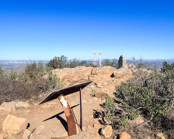
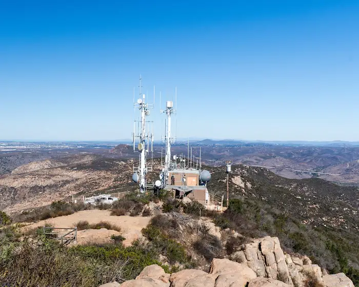
Kwaay Pay Peak lies right over those antennas.
Read More: Annie’s Canyon Trail in San Diego County
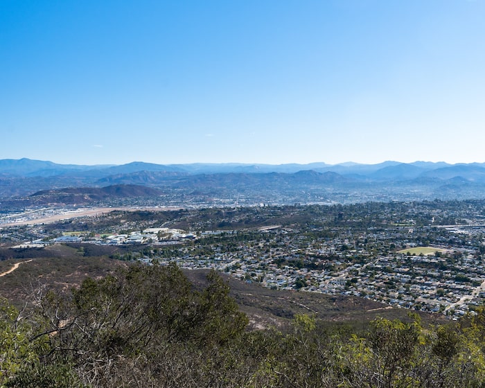
The mountain range in the back is the Cleveland National Forest.
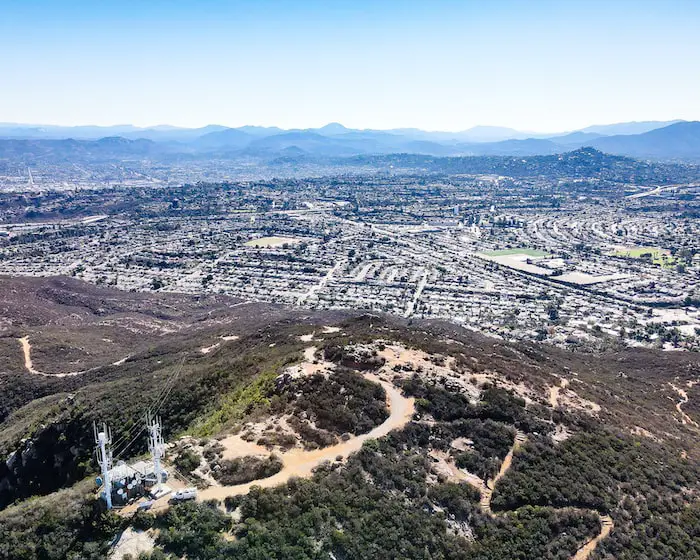
The dirt road is called Cowles Mountain Service Road, and is actually one of the less trafficked alternative routes to the peak, totaling 2.9 miles as a roundtrip loop.
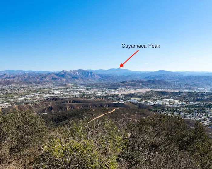
Cuyamaca Peak is the 2nd highest peak in San Diego County, and gets snow in the winter! Fun fact, Hot Springs Mountain is the county’s highest peak.
Read More: 7 Must-Do Waterfalls in Socal
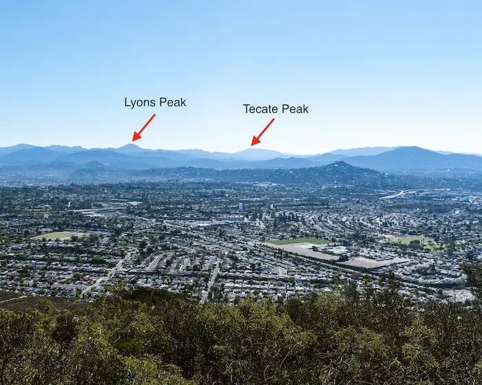
Tecate Peak gets its name because it overlooks the city of Tecate in Mexico, where I happen to have family. It’s also the name of the very popular Mexican beer.
Surprisingly, Tecate Peak is barely located within US jurisdiction.
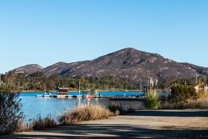
Lake Murray, shown below, can actually be seen almost from the very beginning of the hike, but I saved it for the end because the peak offers the best views.
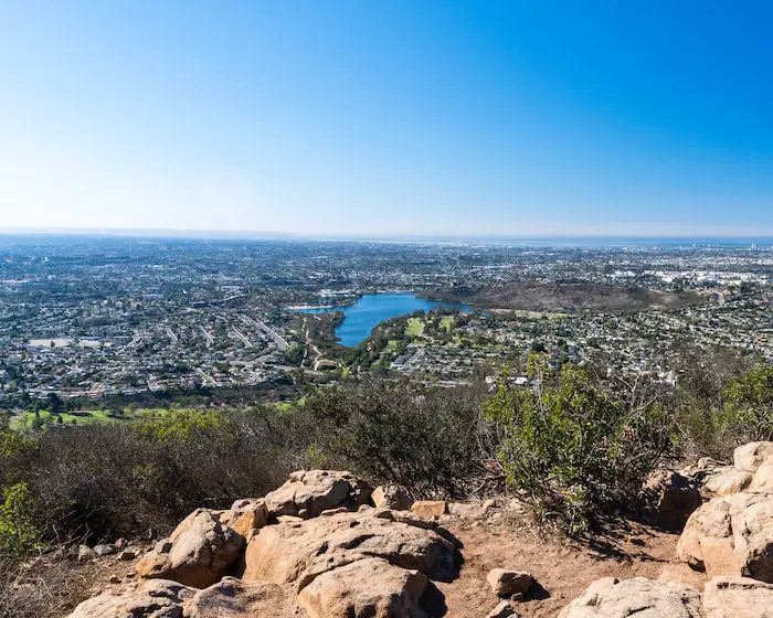
For those who visit the lake, you’ll be rewarded with a stunning backdrop of beautiful Cowles Mountain.
Read More: 7 Best San Diego Hikes You MUST Explore!
Read More: Ho Chi Minh Trail: Slot Canyon + Falls in SD
Cowles Mountain History
Probably the most interesting history fact regarding Cowles Mt, is the fact that a Kumeyaay Winter Solstice site was once located on the trail.
Lasting for a few days before and after the solstice, people were able witness a peak splitting the rising sun to the east. (Thank you Hidden San Diego for this amazing find).
Unfortunately, the peak was destroyed many years ago.
According to MTRP.org Cowles Mountain is named after George A. Cowles, a kind and ambitious man, as well as one of the first San Diego ranchers.
However, the mountain was originally known as S mountain, thanks to 500 San Diego State University students who painted a 400ft tall “S” on the side of the mountain in 1931. The tradition of repainting the letter S lasted well into the 1980’s, but hasn’t been repainted since.
Cowles settled in in El Cajon valley in 1877 and purchased roughly four thousand acres of land, consisting of two ranches known as Magnolia Ranch (if it sounds familiar that’s because it’s now a street name), and Woodside Ranch.
On his ranches, he grew and sold:
- fruit trees
- olives
- potatoes
- olives
- grapevines
He also raised horses and cattle. However, it was Cowles’ fruits and grapevines which attracted the most attention.
Thanks to Cowles, San Diego gained worldwide fame as an ideal farming region.
Although he passed away in 1887, the community which sprung out of his Woodside Ranch became known as Cowlestown.
He left his estate to his beloved widow, Jennie, who continued the ranching legacy until the1890’s. She remarried to Milton Santee, a real estate developer, in 1890 and moved to San Diego City.
Cowlestown became officially known as Santee in 1893 (ouch).
FAQ
Can you hike Cowles Mountain at night?
Yes, people hike Cowles Mountain at night. Especially on weekends, it’s not at all unusual to find lots of people hiking up to Cowles Mountain in the dark.
How many calories do you burn while hiking Cowles Mountain?
Although the answer will vary with each person, you can expect to burn roughly 500 calories on your Cowles Mountain hike.
Is Cowles Mountain hard?
I would rate Cowles Mountain as moderately difficult.
How long does it take to get to the top of Cowles Mountain?
It’ll take you roughly 1.5 hours to reach the top of Cowles Mountain.


