
Pasadena is a beautiful city nestled in the foothills of the Angeles Forest boasting a hiking history that goes as far back as the 1800’s.
I grew up near the City of Roses, as it’s commonly referred to, and actually attended Pasadena City College. Therefore, I’m very familiar with the area.
I’m going to share with you the most beautiful hiking trails in and near Pasadena including a hike to 5 mines, which remain a secret to this day.
Hikes Located In Pasadena
Eaton Canyon Falls (Closed)
- Total Miles: 4.02
- Difficulty: Easy
- Best Season: Mid-Spring
- Elevation Gain: 449 Ft
- Time: 2 Hrs
- Dogs: Allowed On A Leash
- Restrooms: Available At The Trailhead
- Map, Directions, & Full Post: Eaton Canyon Falls
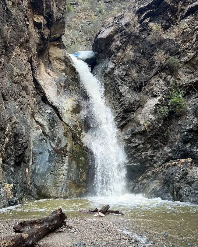
Eaton Falls is located in Northern Pasadena and is the most popular waterfall in the entire Los Angeles National Forest. Get there extra early!
A permit to hike the canyon is no longer needed. The hike begins on a dry dirt road which quickly transitions into a much more amusing single track.
The trail closely follows the creek as you make your way through a beautiful gorge filled with white alders and precipitous cliffs on both sides. Because you’re hiking on the canyon floor you can expect plenty of vegetation and some shade.
There is a decent amount of water in the creek year round, so you can expect multiple creek crossings. However, due to the minuscule amount of rainfall we get in Southern California, the falls are more of a trickle than a waterfall throughout the year.
If you want to see a full-flowing waterfall I highly suggest visiting during the months of April, May, and June. Here’s a fun fact that most people are completely unaware of, there’s a second hidden waterfall right above Eaton Falls.
However, getting to the second falls is extremely dangerous and illegal to attempt unless you’re rappelling your way down the canyon.
Rose Bowl Loop
- Total Miles: 3.08
- Difficulty: Easy
- Best Season: All Year
- Elevation Gain: 129 Ft
- Time: 1 – 1.5 Hrs
- Dogs: Allowed On A Leash
- Restrooms: Available At The Parking Lot & Lawn
- Map, Directions, & Full Post: Rose Bowl Loop
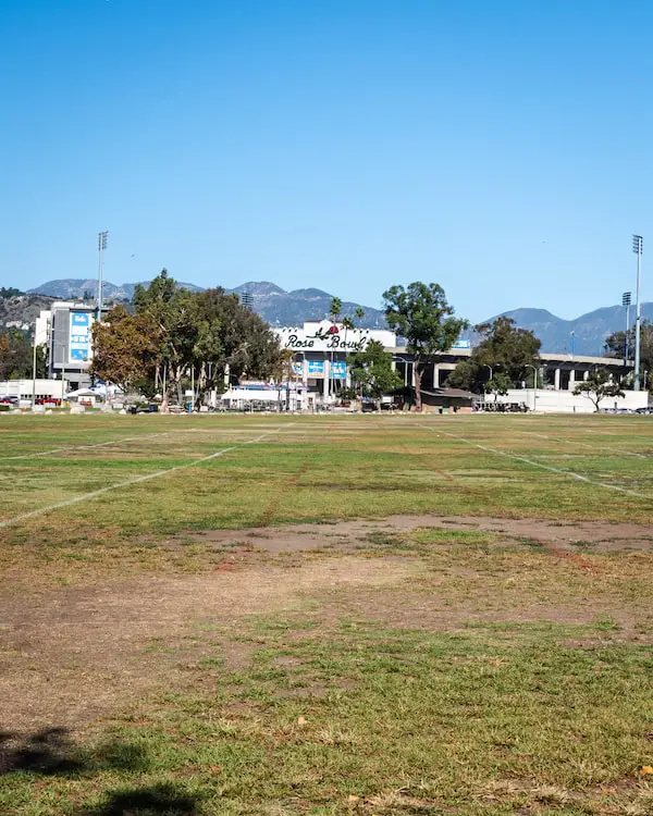
The Rose Bowl Loop is a peaceful hike (in reality more of a walk) around the iconic Pasadena Rose Bowl. This is a great place for kids or beginning hikers to build endurance, but make sure to take plenty of water and a hat because it’s a sunny one!
The Arroyo Seco creek traverses the center of the loop. Fun fact, the Arroyo Seco is the same creek in which Switzer Falls is located, but obviously, much deeper in the mountains.
Various peaks, such as Mt Lowe and Mt Wilson, surround the stadium, forming a picturesque scene along with the Brookside Golf Course located directly behind the stadium.
There are many people walking the loop on any given day, but assuming there are no events at the Rose Bowl, parking is plentiful. The trail is open everyday from 6 am – 7:30 pm.
This is one of the few hikes that is stroller friendly, as the elevation gain is minimal and the entirety of the trail consists of a paved road. Jogging and cycling are also permitted.
Henninger Flats (Closed)
- Total Miles: 5.04
- Difficulty: Moderate – Hard
- Best Season: All Year
- Elevation Gain: 1531 Ft
- Time: 3 Hrs
- Dogs: Allowed On A Leash
- Restrooms: Available At The Flats
- Map, Directions, & Full Post: Henninger Flats
In 1892, Theodore Parker Lukens, an ex mayor of Pasadena and mountain conservationist, created a forest nursery in a hanging basin that is frequently hiked to today.
That nursery is Henninger Flats, a wooded flats located above Eaton Canyon Falls. In fact, both trails share a trailhead. However, getting to the flats requires hiking up Walnut Canyon shortly after the start of the hike, then ascending via the historical road, Mt Wilson Toll Rd.
You don’t have to get to the flats to enjoy amazing views. From about halfway up the hike I was able to see JPL, a lot of the valley, and since it was a clear day, the Pacific Ocean.
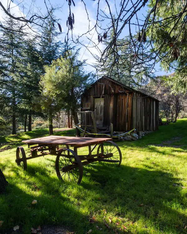
A museum and multiple historical artifacts including a prior fire tower, a cabin pertaining to La Crescenta’s first settler, and the axels of a tram that was once powered by Herbert the mule and used to transport guests from Inspiration Point to Panorma Point.
Henninger Flats is a great place to relax. Huge pine trees shade virtually the entire grassy area, and picnic tables offer crystal clear views, assuming smog levels are low. A water fountain and restrooms are also located at the flats.
However, the majority of the hike is completely exposed to the sun, so plan accordingly.
Ruins At Echo Mountain (Closed)
- Total Miles: 6
- Difficulty: Moderate
- Best Season: Mid-Spring
- Elevation Gain: 1566 Ft
- Time: 2.5 – 3 Hrs
- Dogs: Allowed On A Leash
- Restrooms: Not Available
- Map, Directions, & Full Post: Echo Mountain
In my opinion, the ruins of the resort located at Echo Mountain are the most fascinating part of Pasadena’s history, and a must see for everyone. In 1893 Professor Thaddeus S.C. Lowe built the electric Mt Lowe Railway, a cable funicular railway known as the Great Incline, and White City, essentially a theme park combined with a mountain resort.
From the pavilion in Rubio Canyon, tourists would take the Great Incline to Echo Mt House (AKA Echo Mt Hotel) where they would have the option of transferring to a Mt Lowe Railway trolley and heading up to Ye Alpine Tavern.
Unfortunately, due to a series of fires and floods, all of it was destroyed.
Today we can hike up to the Echo Mountain ruins via the Sam Merrill trail that begins at the Cobb Estate off of Lake Ave. The majority of the trail is sunny and consists of multiple switchbacks.
Make sure to take plenty of water and a hat. Once you reach your destination you can enjoy views of Pasadena and explore the ruins of the chassis, observatory, powerhouse, and the Great Incline.
Did I mention I found a secret waterfall across the canyon? You can see those pictures by clicking on the full post above.
Secret Mines of Las Flores Canyon
- Total Miles: 2.1
- Difficulty: Moderate
- Best Season: All Year
- Elevation Gain: 620 Ft
- Time: 1 Hrs
- Dogs: Allowed On A Leash (Not Recommended For Dogs)
- Restrooms: Not Available
During the Gold Rush of the 1800’s miners excavated roughly 300 mines throughout the San Gabriel Mountains. The mines at Las Flores Canyon were built from 1893-1894 by a man named Wiliam Twadell and his mining company.
Click here to get access to the secret Las Flores Mines!
William staked multiple mines in the area, some of which are known as the Golden Star, Monitor, and Bald Eagle, but shortly thereafter abandoned the operation due to water shortages, a common issue for miners at that time.
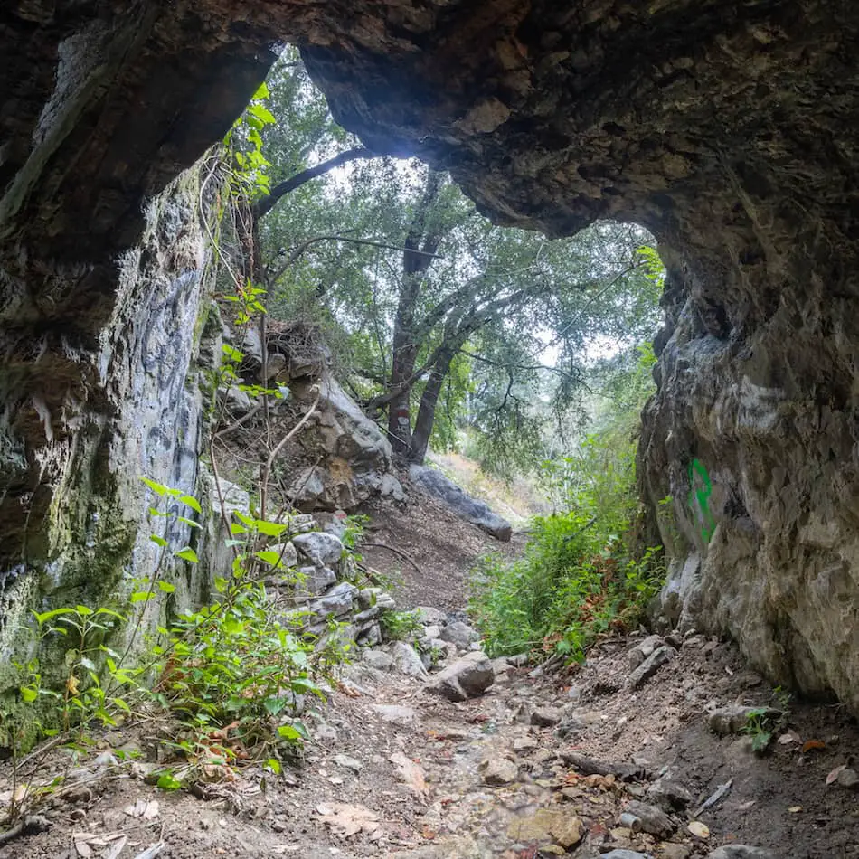
Today you can venture to the mines via a quick hike that begins at the Cobb Estate, just like the Echo Ruins. Instead of taking the single track that takes you across the canyon and leads up the mountain, you continue up the cement road and then switch onto a single track that leads you back down to the canyon floor.
It’s a very short and rewarding hike with a decent amount of shade and an abundance of vegetation. The hike has a few very narrow sections with steep ledges and requires climbing down a 10-foot rocky face wall.
Hence, I don’t recommend this trail for individuals who are not in acceptable shape and have good balance. This is definitely not a hike for small children.
Once you get to the last mine you can venture inside and explore for about 100 feet before you reach a dead end. Depending on the season, you may have to trek through shin-deep water to reach the end.
Hikes Near Pasadena
It would be a shame not to share with you a few amazing hikes that are not in Pasadena but just around the corner. These hikes used to be in my “backyard,” so if your goal is to hike in or near Pasadena, I can assure you you won’t be dissatisfied.
Mount Lowe Peak (Closed)
- Total Miles: 3.04
- Difficulty: Moderate
- Best Season: All Year
- Elevation Gain: 623 Ft
- Time: 1.5 Hrs
- Dogs: Allowed On A Leash
- Restrooms: Not Available
- Map, Directions, & Full Post: Mt Lowe Peak
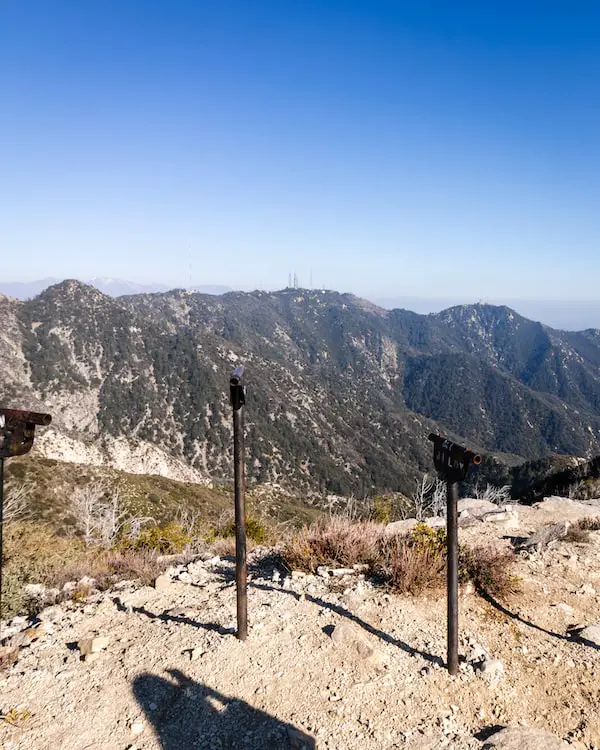
Mount Lowe Peak, named after Professor Lowe who built the Rubion Pavilion, is famously known for the swing set located at the peak that allows you to literally “swing above the clouds,” as you enjoy the Pasadena views.
In all other directions, you’ll find yourself surrounded by various peaks such as Mount Wilson, San Gabriel Peak, and Mount Disappointment.
You can reach the peak from the Cobb Estate (a 9+ mile hike) or you can begin from Eaton Saddle to shorten the hike to 3.2 miles. If you choose the Cobb Estate as your trailhead you can make a quick pit stop at the Echo Ruins and Inspiration Point further up the mountain.
If you decide to hike from Eaton Saddle you will be required to drive approximately 21 miles from Pasadena up the 2 hwy. The drive features multiple mountain ranges, so I don’t mind at all.
I prefer the route via Eaton Saddle, not only because it’s shorter, but also because the trailhead is at an elevation of 5110 ft, which means more pine trees, better views, and cooler temperatures.
You also get to walk through the super awesome Mueller Tunnel that used to be part of the Mount Lowe Railway. The trail is mostly exposed. However, if you decide to bag this peak in the winter months you may be surprised to see snow!
Millard Canyon Falls
- Total Miles: 1.3
- Difficulty: Easy
- Best Season: Spring
- Elevation Gain: 308 Ft
- Time: 45 Min
- Dogs: Allowed On A Leash
- Restrooms: Available At The Campground
- Map, Directions, & Full Post: Millard Canyon Falls
Millard Falls is a very short hike located in Altadena, Pasadena’s neighboring city. The trail begins at Millard Campground and makes its way along the creek until you get to the 50-foot falls.
Almost the entirety of the trail is located under the forest canopy and requires multiple creek crossings. White alders and Western Sycamores crowd the narrow canyon and make you feel like you’ve genuinely left the city far behind. It’s the perfect hike for beginners.
Like many waterfall hikes in the San Gabriel’s, the creek contains some amount of water year-round, but the falls reduce to a trickle when summer begins.
Fun fact: Millard Falls used to be known as Church Canyon because the early settlers used the lumber from this canyon to build the Plaza Church in Los Angeles. It was later named after Henry W. Millard who resided in the canyon in 1862.
Dawn Mine Trail
- Total Miles: 4.66
- Difficulty: Moderate
- Best Season: All Year
- Elevation Gain: 1175 Ft
- Time: 2.5 – 3 Hrs
- Dogs: Allowed On A Leash
- Restrooms: Not Available
- Map, Directions, & Full Post: Dawn Mine Trail
The Dawn Mine Trail is a moderately difficult-rated trail located in Altadena. The mine was founded in 1895 by a man named Bradford Peck who worked on it for 7 years before closing it down to a lack of success.
The trail begins by leading you down into Millard Canyon above Millard Falls and through the canyon floor until you reach the Dawn Mine.
Bonus Tip: If you can’t find parking at the trailhead, you can begin the hike from the same parking lot intended for Millard Falls, and walk up the same road you came down on or, if you prefer a short faster route, you can hike up a single track that ends at the Dawn Mine trailhead.
Since the trail follows the creek for the majority of the hike be prepared for a few creek crossings. There is lots of vegetation inside the woodsy canyon and therefore a good amount of shade.
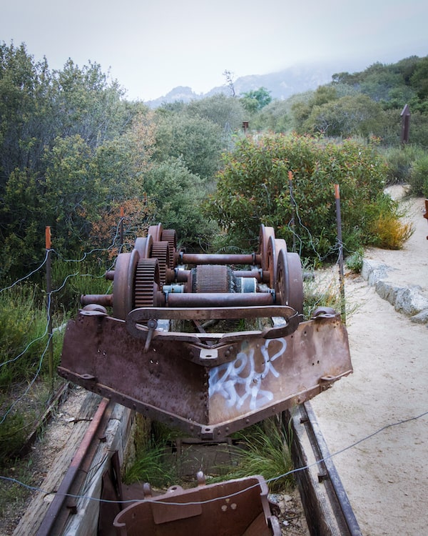
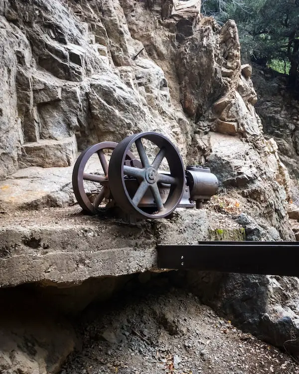
Unfortunately, the mine has been closed to the public for a few years now, but you can still peek inside or check out the super cool water pump that was used for the mine.
If you hop back onto the single track after exploring the Dawn Mine, you’ll very shortly run into an exploratory dig on the left side of the trail which you can actually venture inside of and explore. It’s only about 50 feet long but totally worth the time!
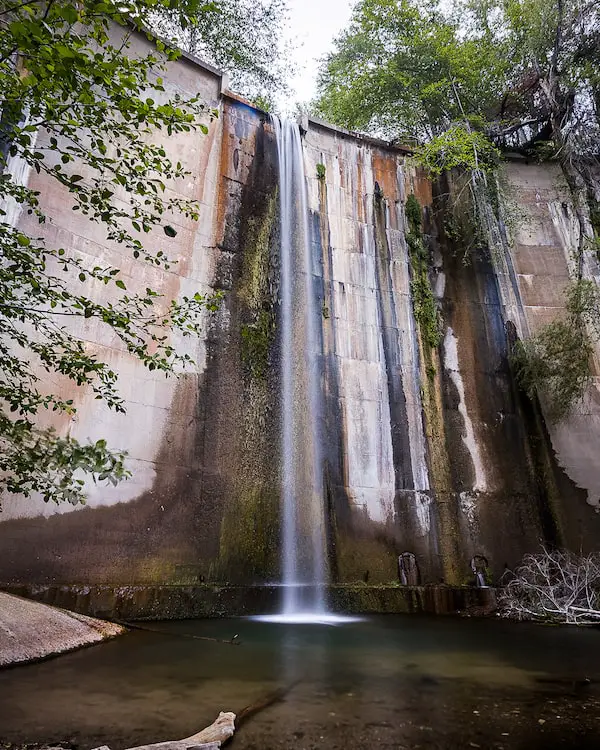
Brown Mountain Dam Falls
- Total Miles: 1.45
- Difficulty: Moderate
- Best Season: All Year
- Elevation Gain: 663 Ft
- Time: 1.5 Hrs
- Dogs: Allowed On A Leash
- Restrooms: Not Available
- Map, Directions, & Full Post: Brown Mountain Dam Falls
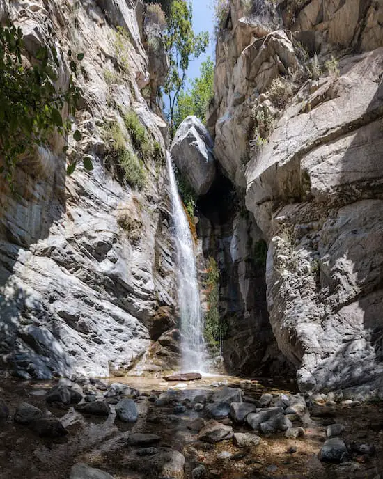
The 80 foot waterfall at Brown Mountain Dam may be man made, but it’s nothing short of exceptional. There are various trails you can hike to get to the falls, ranging from 2 – 8.4 miles.
If you’re trying to avoid an 8-mile hike, I found a 2-mile shortcut that begins off of the 2 hwy. It’s very steep and slippery in a few sections, but nothing too crazy. Either way, I don’t recommend this route for small children.
The first half of the trail quickly descends onto the canyon floor where you’ll be surrounded by tons of greenery and the beautiful Arroyo Seco creek. The ruins at the Paul Little Picnic area give off an eerie vibe.
If you hike in the evening, the sun rays shine through the white alders and illuminate the creek water. It’s paradise.
The waterfall forms a shallow pool at its base, and the moss on the dam provides a feeling of nature taking control of man’s creation.
You’ll be surprised at how fast the setting changes on this short 2 mile hike. I highly recommend it.


